DOI: 10.14714/CP103.1835
© by the author(s). This work is licensed under the Creative Commons Attribution-NonCommercial-NoDerivatives 4.0 International License. To view a copy of this license, visit http://creativecommons.org/licenses/by-nc-nd/4.0.
US Navy Aerial Photography Squadrons in Türkiye: American Interests in Cold War Cartography
Christopher H. Roosevelt, Koç University | chroosevelt@ku.edu.tr
This article explores a little-known archive of historical aerial photographs curated by the General Directorate of Mapping of the Republic of Türkiye’s Ministry of Defense and discusses the historical context of their production by US Navy aerial photography squadrons in the 1950s. While the images themselves enable a technical analysis of the method of their collection, contemporary military manuals, domain-specific magazines and newsletters, and eyewitness accounts of how similar photographs were captured fill out the contexts of their production for cartographic purposes, with information about the aircraft involved, their cameras and camera configurations, and mission characteristics. Continuing sections situate the aerial surveys within the framework of US-led initiatives in mapping NATO territories following World War II. As one example of what must have been many special mapping agreements made between NATO countries at this time, the US cartographic surveys over Türkiye discussed here are an expression of postwar realignments of global power, put to the purposes of containment-based security preparations and infrastructure development, and neatly intertwining American military and commercial interests early in the Cold War.
KEYWORDS: historical aerial photographs; cartographic production; US Navy; Türkiye; NATO; Cold War
INTRODUCTION
When Koç University’s Research Center for Anatolian Civilizations (ANAMED) embarked on the development of a project aiming to provide a resource for the study of past Anatolian landscapes, it inadvertently came across a little-known archive of historical aerial photographs. Collected for cartographic purposes, these images engage with topics including United States–led NATO security concerns, the Cold War Americanization of global geography, and the convergence of cartographic and commercial imperialism within US-led exploration and infrastructure development in the light of post-World War II realignments of global power. These realizations were not clear at the time, of course, when ANAMED’s primary interests included exploring the analytical potential of sets of archival aerial images covering the entirety of Türkiye (Hong and Roosevelt 2023). A broad inquiry had been made to the General Directorate of Mapping, part of the Republic of Türkiye’s Ministry of National Defense, concerning the availability of stereoscopic sets of historical aerial photographs that had continuous coverage of the country. The earliest dataset that met these criteria was from the 1950s, and the first partial-coverage orders were placed. Delivery of scanned images was accompanied by minimal metadata, including—among other baseline information—reference to it as the “Amerikan” collection. As initial processing and study of the dataset progressed, it quickly became apparent that this American collection of aerial photographs derived from an otherwise secretive cooperation between Türkiye and the US throughout the mid-1950s that involved a little-celebrated yet incredibly productive cartographic squadron of the US Navy.
Similar collections of twentieth-century aerial images have been discussed with varying cartographic approaches in mind. Critical analyses have highlighted technical, artistic, and cognitive perspectives (e.g., Sekula 1984, 33–52; Sichel 2007; Cosgrove and Fox 2010), while consideration of the role of aerial images in the social production of space has explored their totalizing, contextualizing capacity in structuring understandings of built environments (e.g., Haffner 2013). The map-like images that resulted from the coalescence of aviation and photography, and eventually their transformations into photogrammetrically corrected orthophoto mosaics (Cosgrove 2008; Dyce 2013), suggested a sense of depersonalized objectivity associated with an Apollonian or God’s eye view (Virilio 1989; De Landa 1991; Cosgrove 2001; Kaplan 2018), and gave new meaning to the idea of the “high ground” in military contexts (van Crevald 1991, 120–27; 2011; Brugioni 2010; Barney 2014). Produced by the US Navy, the military nature of the current collection is implicit, even if similar collections were used for academic, civilian, and commercial purposes (Saint-Amour 2011).
Like most Cold War geospatial information and technologies, as explored by John Cloud, John Clarke, and others, the aerial photographs in this collection and the US Navy squadrons that produced them remain obscured by a lingering haze of secrecy (e.g., Cloud and Clarke 1999; Cloud 2002; Truesdell 1953). Brian Harley (2001b) demonstrated how cartography and its products have always been potent discursive tools in politics and power, and the images in this collection are no different. Imprinted with “US Navy” and “Top Secret,” the photos signpost their significance early in the Cold War, at a time when concealing the technologies that underlaid geographic knowledge production was paramount.
Others have commented on the US military’s assembly-line methods of geographic knowledge production during and after World War II (e.g., Sekula 1984), encapsulated in the processing of hundreds of thousands of aerial photos into usable cartographic tools with “relentless graphic uniformity” (Rankin 2016, 84). Rather than focus on their processing, this article focuses on the initial capture of aerial images in aerial surveys and the historical contexts that led the US Navy to Türkiye for this purpose. As such, the article aligns most closely with traditions Matthew Edney (2014, 94) describes as “processual map history,” with coverage of both the technical aspects of aerial photographic production and the historical contexts that enabled them. The article also follows Matt Dyce (2013), whose critical cartographic approach explored the representational, map-like nature of vertical aerial photographs, and how photogrammetric processing into depersonalized, technically objective images made them only more map-like (see also Cosgrove 2008; Daston and Galison 2007). Aerial images and maps are thus conflated in this article, and the term “cartographic” is used only in one of its traditional senses, in relating to mapmaking. “Cartographic squadron,” “cartographic survey,” “aerial survey,” and “aerial imaging,” then, all refer to the same practice: systematic aerial photographic survey conducted by specifically trained units with the aim of collecting images for photogrammetric processing into standardized and accurate maps.
Just as “maps inevitably codify the interests and worldviews of their makers” (Rankin 2016, 13; see also Woods and Fels 1992; Harley 2001a), so too are mapmaking practices imprinted with the underlying tendencies of those who commission them. In this case, the specific practices of aerial photographic surveys in Türkiye reflect postwar realignments of global power and the technocratic and imperializing military and commercial incentives that supported them (see also Immerwahr 2019). To reach this conclusion, this article works backwards, beginning with a characterization of the images based on their imprinted information. A Geographic Information System (GIS)-enabled analysis of survey missions over Türkiye is then complemented by embodied understandings deriving from archival research, US Navy aerial photography manuals, domain-specific magazines and newsletters, and eyewitness accounts. Together, these sources fill out the contexts of image production by aerial mapping squadrons in the 1950s, with information about the aircraft involved, their cameras and camera configurations, and mission characteristics. This article goes on to discuss these aerial surveys within the framework of US-led postwar initiatives in mapping that were rallied to the dual causes of security preparations and infrastructure development that neatly intertwined American military and commercial interests along NATO’s Southern Flank early in the Cold War.
TECHNICAL CHARACTERISTICS OF THE PHOTOGRAPHS AND THEIR PRODUCTION
The request for historical aerial photographs described above resulted in the delivery of scanned panchromatic images by early 2021. Metadata delivered with the images themselves included spreadsheets and other files with filenames such as “Amerikan,” “Amerft,” or “fotoamerikan,” containing a selection of information for each image including date, year, roll number, exposure number, latitude and longitude (in decimal degrees), focal length, and scale, the latter referring to photographic scale, or the ratio of camera focal length to elevation. Four additional data columns—type, size, direction, and purpose—were mostly empty, except for direction, which sometimes recorded cardinal directions, and purpose, which sometimes recorded “amerikan.” It quickly became apparent that the supplied metadata represented only a selected collation of the information available in the camera-printed labels. Also apparent was an explanation for references to the collection as “American,” as each image was stamped with “USN” (for US Navy), along with squadron and detachment identification, among other information (Figure 1).
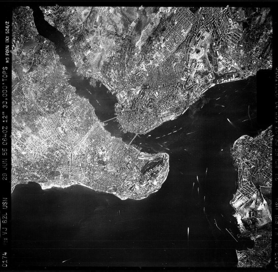
Figure 1. Representative sample of the historical aerial photographs in the collection, this one captured in late June 1955 above the historical peninsula of Istanbul, and surroundings, with north near the top. Note the camera-printed label shown here along the left side of the frame.
Review of the camera-printed labels of the collection demonstrated that the images were captured between July 1953 and May 1957 by detachments of the VJ-62 and, later, VAP-62 squadrons of the US Navy, with each detachment identified by an alphabetic suffix adopted from the 1947 version of the International Civil Aviation Organization’s Radiotelephony Spelling Alphabet, beginning with Able, Baker, Charlie, etc. (Ginter 1992, 70). Photographs from 1953 and 1954 share the same two-line labeling format, with the label located at the bottom of the frame with respect to the direction of flight (Figure 2). These labels usually include the following information: exposure number; squadron-detachment identification; film roll and run (transect) number; date; focal length (in mm or inches); elevation (in feet); camera orientation (V for vertical, VL and VR for vertical left and right, respectively); coordinates (in degrees and minutes); time of run start (with suffix Z); and varying additional text, usually including at least “TKY” (for “Türkiye”) “TOP SECRET,” and “NO FORN,” for “No Foreign” access or distribution.
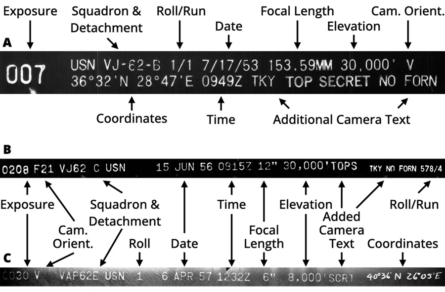
Figure 2. Examples of camera-printed labels on historical aerial photographs in the collection. A: label format used in 1953–1954; B: label format used in 1955–1956; C: label format used in 1957, including hand-annotated coordinate data.
Similarly, photographs from 1955 and 1956 share a common single-line labeling format containing similar information, now with the label located at the top of the frame with respect to the direction of flight. Exceptions in 1955 and 1956 include coordinates that are handwritten, when included at all, and LO and RO camera orientations, for left and right oblique, respectively. Additionally, F21 and F22 sometimes replace the L- and R- camera orientations in images from 1956, respectively, “TOPS” is another abbreviation for “Top Secret,” and roll and run information appears after the additional text.
Camera-printed labels from 1957 again appear at the top of the frame with respect to the direction of flight and are even more abbreviated, with “SCRT” substituting for “Top Secret” and with handwritten coordinates, if included at all.
With the additional exception of pre-printed labels on negatives that identify film manufacturer and type (often “KODAK RECON SAFETY” or “KODAK AEROGRAPHIC SAFETY FILM 1A” (or “1B”)), this is the extent of the metadata available for the collection. General Directorate of Mapping sources suggest the images were scanned in its Department of Photogrammetry at a resolution of 20-microns with a positional accuracy of ±2 microns (Erbaş 2013, 28–29; HGM Hava Fotoğrafı 2023), yet no other information useful for precision photogrammetric processing is known (e.g., camera calibration, lens distortion, principal point, or fiducial mark information). Nonetheless, from this information alone, a general sense of the cartographic missions that produced the archive was produced by reconstructing flight lines and overall coverage with the aid of GIS software.
Over the course of at least five years and involving at least VJ-62’s Baker (B), Fox (F), Love (L), and Charlie (C) Detachments in 1953, ’54, ’55, and ’56, respectively, and VAP-62’s Easy (E) Detachment in 1957, at least 147 days of flying produced the nearly 60,000 images in the collection as of 2021 at a variety of photographic scales, apparently dependent on mission goals (Figure 3; Table 1). At present, it seems that only one plane from each detachment each year provided all the photographic output of the collection. Over 30 days in 1957, work focused on a large photographic-scale survey of Aegean coastal areas at 1:16,000 (12,837 images captured at 8,000 ft), with a small area covered by 1:8,000 (60 images captured at 4,000 ft) and the coastline itself by 1:10,000 scale imagery (2,301 images captured at 5,000 ft) (Figure 4). The larger body of work over 117 days between July 1953 and July 1956 was dedicated to broadscale mapping. Current holdings cover all parts of western Türkiye located west of a roughly north-south line running from near Karadeniz Ereğli, Zonguldak, to Manavgat, Antalya, represented by a total of 10,870 1:60,000 photographic-scale images and 33,054 1:30,000 photographic-scale images, all collected from 30,000 ft.
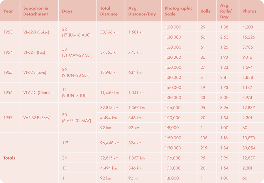
Table 1. Flight days, distances, and photographic production derived from nearly 60,000 images and their camera-printed labels.
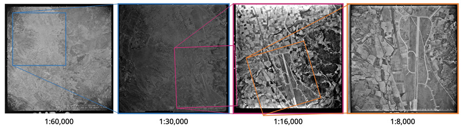
Figure 3. Examples of collection images, exhibiting different photographic scales as well as the differing quality of the image exposures. Here the focus is on the Cumaovası airfield, what later became the Izmir Adnan Menderes Airport in Gaziemir, Izmir.
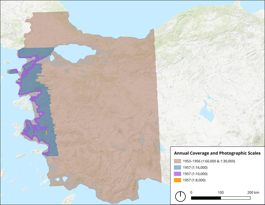
Figure 4. Map showing the geographic coverage of cartographic survey represented by the selection of data currently being processed.
In each of the 1953–1956 flights, a combination of cameras with lens cones of different focal lengths were used to capture overlapping sets of images for stereoscopic and photogrammetric analysis (see below). A 6-inch focal-length prime vertical camera recorded a series of fore-lapping images at 1:60,000 photographic scale; these were likely used for flight-path monitoring, orientation, and subsequent larger-scale image localization. Simultaneously, a pair of 12-inch focal-length split vertical or slightly oblique cameras recorded sets of fore- and side-lapping exposures at a photographic scale of 1:30,000. Parallel runs or transects crisscrossed the landscape producing sets of contiguous images suitable for producing topographic maps at scales of around 1:25,000 (Figures 5–6).
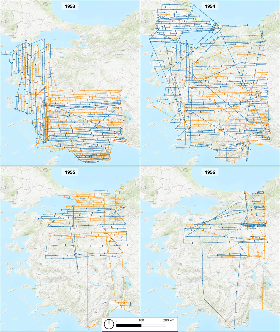
Figure 5. Maps showing the daily flight lines for 1953–1956 surveys and capture of 1:60,000 and 1:30,000 photographic scale images. Alternating line colors indicate different days.
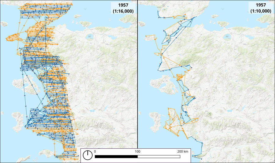
Figure 6. Map showing the daily flight lines for 1957 survey and capture of 1:16,000 and 1:10,000 photographic scale images. Alternating line colors indicate different days.
As apparent in Table 1 and Figures 5–6, the intensity of work seems to have been highest in 1953 and 1954, judging by total distances covered and numbers of rolls and photos captured. The work of 1955 and 1956 appears to have aimed to fill gaps between the flight lines of previous years. Work in 1957 was intensive, also, as shown in the total distances covered, and the high numbers of rolls and photos derives from the lower altitude of the flights, which produced more detailed images at larger photographic scales. Average distances and rolls per day appear to fall within the ranges of other cartographic surveys of the time (see below), yet a few longer-distance outliers are evident. On 11 August 1953, for instance, Baker (B) Detachment of VJ-62 logged at least 3,267 km along survey runs alone—not including round-trip distances to landing strips, that is; the result was 3 rolls or 493 images at 1:60,000 photographic scale and 5 rolls or 1,672 photos at 1:30,000 scale. On 1 May 1957, Easy (E) Detachment of VAP-62 logged at least 4,205 km along survey runs and captured 9 rolls or 1,538 photos at 1:16,000 photographic scale.
Beyond this baseline-level of information reverse-engineered from the camera-printed labels, little more can be reconstructed about the collection images and the squadron that captured them. To learn more, one must zoom out and step slightly back in time to US Navy archives and aerial photography training manuals, as well as related magazines and newsletters, which illuminate the rich history of the US Navy’s involvement in aerial photographic reconnaissance and cartography.
US NAVY AERIAL PHOTOGRAPHY SQUADRONS IN THE 1950s
The development of aerial photographic capacity in World War II (WWII) had significant impacts on the planning, implementation, and post facto assessment of wartime maneuvers in reconnaissance, tactical intelligence, and mapping (see Babington-Smith 1957; Heiman 1972; Goddard 1969; Brookes 1975). Wartime aerial photography missions of the US Navy were undertaken by mixed squadrons of fighter and bomber aircraft which were carrier- or land-based, designated Composite Squadron Sixty-One (VC-61) in the Pacific Fleet and Sixty-Two (VC-62) in the Atlantic Fleet (DeForge 1981, 3-10). Soon after WWII, these squadrons were reassigned and redesignated to suit administrative changes and narrowed functions. By 1951, it was decided that the fighter elements of VC-61 and VC-62 would focus on reconnaissance and tactical intelligence photography based primarily from carriers, while the bomber elements would be broken off to form Photographic Squadrons Sixty-One and Sixty-Two (again with Pacific [VJ-61] and Atlantic [VJ-62] designations), dedicated to long-range reconnaissance and cartographic surveys based typically from land, but also from carriers (Naval Aviation News 1953c; 1956a; 1958c, 8; DeForge 1981, 3-10; Campbell 2014, 361).
Accordingly, VJ-62 was commissioned in April 1952 with a home port at the US Naval Air Station (NAS) in Jacksonville, FL (Jax Air News 1952; Grossnick 1995, 314). Over the next five years, the home port of the squadron changed several times—to Sanford, FL, Norfolk, VA, and back again to Jacksonville, FL (Grossnick 1995, 314)—while its missions remained relatively constant in supplying reconnaissance for the Atlantic Fleet and mapping and other photographic services for a variety of US and foreign entities, especially around the Mediterranean. In July 1956, the Navy’s photographic squadrons were again redesignated according to new organizational and naming logic: the fighter-based reconnaissance and tactical VC squadrons were redesignated as Light Photographic Squadrons (VFP), and the long-range, bomber-based VJ squadrons were redesignated as Heavy Photographic Squadrons (VAP), again with Pacific (61) and Atlantic (62) designations (Naval Aviation News 1956b; DeForge 1981, 3-17; Grossnick 1995, 314). As is clear from the camera-printed labels in this collection, it was the bomber-based VJ/VAP-62 photographic squadron that focused its long-range and cartographic capabilities on Türkiye, the Mediterranean, and further afield (see below).
AIRCRAFT AND CAMERAS
In the first year following their commission in 1952, the VJ squadrons still used Consolidated Aircraft’s WWII-era four-prop PB4Y “Liberator” bombers, modified for photoreconnaissance and designated P4Y-1P (Figure 7A; DeForge 1981, 3-7; Grossnick 1995, 315, 496). Already by the end of 1952, however, the squadrons began flying what would become their workhorse aircraft for much of the rest of the decade: North American Aviation’s AJ “Savage” bomber, with turbojet and twin wing-mounted, reciprocating engines (Figures 7B and 7D; Doeppers 1972, 185; DeForge 1981, 3-10). Capable of both carrier and land deployment and modified as the AJ-2P for aerial photography, the Savage was more versatile than the Liberator and provided the best available long-range aerial photography solution at the time (Grossnick 1995, 315, 458). Owing to design and functional improvements, a version of Douglas Aircraft’s A3D “Skywarrior” bomber, modified for photoreconnaissance and designated A3D-1P (and later A3D-2P), began to replace the Savage in VJ squadrons only five years later (Figure 7C), yet the Savage remained the aircraft of choice for most of the 1950s (Naval Aviation News 1958a; DeForge 1981, 325; Grossnick 1995, 315, 444, 551; US Navy Patrol Squadrons 2024a).
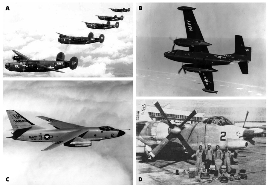
Figure 7. A selection of the aircraft employed in VJ/VAP-62 squadrons in the 1950s, showing tail codes “TP” (before July 1, 1957) and “GB” (after). A: Consolidated Aircraft’s P4Y-1P “Liberators” from VJ-62. B: North American Aviation’s AJ “Savage” from VJ-62 (note the underside camera windows). C: Douglas Aircraft’s A3D-2P “Skywarrior” from VAP-62. D: North American Aviation’s AJ-2P “Savage” from VAP-62, behind camera equipment and crew. All images from the US Navy, obtained via Wikimedia Commons, uploaded by contributor Cobatfor (Grossman 1995, 315).
In addition to its long range, the Savage allowed for a versatility of carrier and land-based options, capacity for deploying flares (or “flash bombs”) for night photography as well as in-flight changing of cameras and film magazines, and a spacious camera bay for accommodating diverse configurations of fixed vertical and oblique cameras (Figure 8; Doeppers 1972, 185; DeForge 1981, 3-7, 3-18). It is no wonder that the US Navy ordered 23 photoreconnaissance-readied AJ-2P Savages in 1950, even if VJ-62 operated only around 7–10 aircraft at any one time throughout the decade (Doeppers 1972, 185; Ginter 1992, 67).
The camera equipment typically used by these squadrons was similar to that used in WWII photoreconnaissance, yet with intermittent upgrades (DeForge 1981, 3-3). For fixed cartographic cameras, the US Navy used the WWII-era Fairchild Camera and Instrument Corporation’s K-17 (CA-3-2) and its derivatives, as well as the newer T-11 (CA-14), specifically built for mapping (NTPC 1962, 198–199; El Hassan 1978, 19). These cameras’ large-format and adaptability to lens cones of varying focal lengths (6, 12, or 24 inches, most made by Bausch and Lomb) enabled large-area coverage while maintaining high-resolution at relatively high altitudes, making them some of the longest running and most versatile cameras long after WWII (Figure 9; NTPC 1962, 201–209; El Hassan 1978, 16, Figure 10, 21; Thomas 1999, 249, Figure 323). The different camera-printed label formats on the images in the current collection may suggest the updating of camera equipment over time.
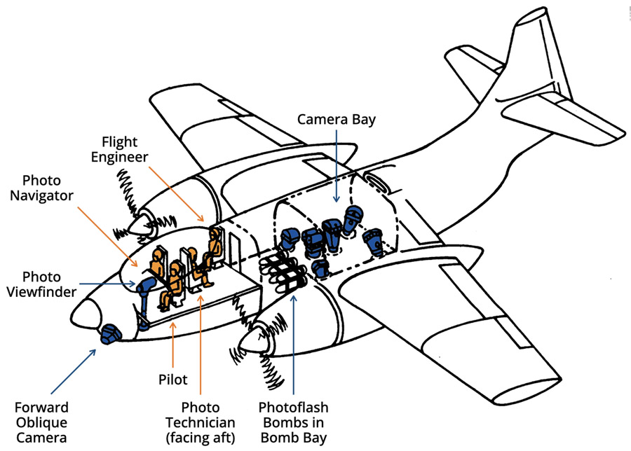
Figure 8. Schematic diagram of North American Aviation’s’s AJ-2P “Savage,” refitted for cartographic photography, showing crew in orange and camera equipment in blue (after DeForge 1981, 3-25).
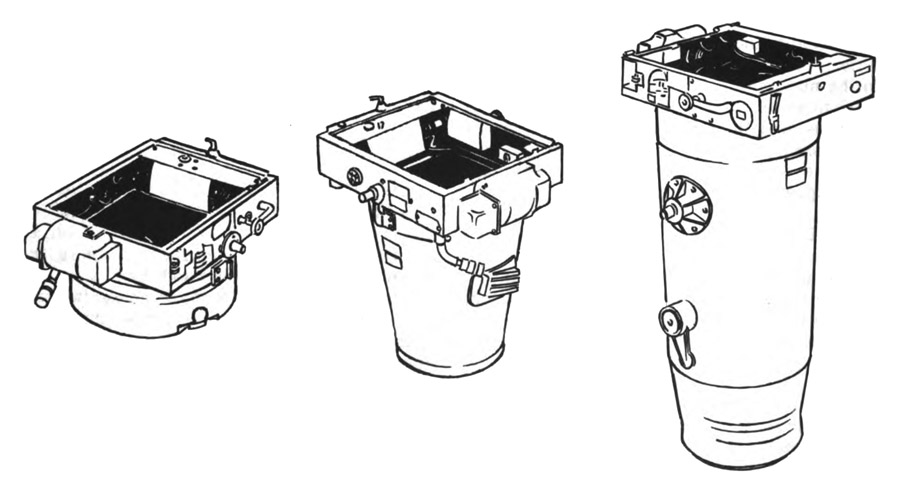
Figure 9. Schematic drawings of the Fairchild K-17 camera with 6, 12, and 24-inch lens cones, from left to right (after NTPC 1962, 188, Figure 11-1).
The shutter mechanism of these cameras was triggered either manually or electrically from a camera control panel near the cockpit; vacuum-sealed film magazines could hold enough 9½-inch film to capture around 225 or 465 9 × 9-inch exposures, depending on magazine size (NTPC 1962, 193; 194; 198). Kodak was the primary film supplier, with its reconnaissance or aerographic safety film the primary options (NTPC 1962, 211).
One common fixed-camera configuration for simultaneous cartographic image capture included what was referred to as a “trimetrogon fan,” including an array of oblique and/or vertical side cameras with 12-inch lens cones and centrally located vertical cameras with 6- or 12-inch lens cones (Doeppers 1972, 185; DeForge 1981, 3-7; 3-18; US Navy Patrol Squadrons, 2024a quoting Harold L. Murphy; Redweik et al. 2010, 1009). This set up was apparently common in the AJ-2P Savage as well as in other WWII and Korean War-era aerial photographic squadrons using different aircraft and cameras (e.g., Mahan 2003, 34–35; Cahill 2012, 14; Schuster 2016). Most photographs, including those covering Türkiye, appear to have been captured using a configuration involving a 6-inch prime vertical and a pair of 12-inch split vertical or oblique cameras.
CREWS AND DEPLOYMENTS
To operate both the aircraft and camera systems successfully, the AJ-2P Savage accommodated a crew of four: a photo technician, photo navigator, pilot, and plane captain (Naval Aviation News 1958c, 8). The photo technician (officially designated a “Photographer’s Mate”) was intensively trained on full-scale mockups in Pensacola, FL at the Naval Aviation Technical Training Unit (DeForge 1981, 3-3; 3-18). In fact, all crew members had to be familiar with the operation of both aircraft and camera systems in order to work together seamlessly, as described in the Navy Photographer’s Mate Training Series: Naval Photography (e.g., NTPC 1962; DeForge 1981). In order to capture high-quality imagery, care in piloting had to be matched by care in proper camera settings and operation.
As described in popular naval magazines and eyewitness accounts, pilots had to maintain steady headings for up to 400 km, regardless of altitude, while ensuring minimum lateral drift; photo navigators served as co-pilots, directing pilots to position aircraft directly over targets while computing ground speed, drift, and other flight data. Photo technicians translated flight data into camera settings, ensuring the capture of desired image parameters, while managing cameras and film before, during, and after flights (see Figure 8) (Naval Aviation News 1958c, 8). The skilled endurance of AJ-2P Savage crews and aircraft are shown in two flight-time records set in 1953 alone: 91 hours in March and 117.7 hours in July (Naval Aviation News 1954). Other records suggest that daily missions were planned with round-trip distances of around 1,100 km (ca. 600 nautical miles; Naval Aviation News 1953), even though at cruising speeds of around 370 kph (230 mph), the AJ-2P had a range of more than 2,500 km (ca. 1,600 miles) (Doeppers 1972, 185). As noted above, several flight days over Türkiye logged far greater distances than these, suggesting mid-day refueling or the use of extra fuel tanks, as described below.
Eyewitness accounts help give a sense of what participating in a VJ/VAP-62 mission in an AJ-2P Savage would have entailed. DeForge (1981, 3-25–26) quotes former Photographer’s Mate J. D. Smyth directly:
. . . In flight, the photographer would be found either at his seat at the camera control panel, on the flight deck behind the pilot, or in the camera bay.
To get to the camera bay, you went down a ladder to the well deck, aft through a hatch, across the bomb bay, and through another hatch. There a photographer could change magazines in flight, change camera settings, even correct minor equipment problems.
The photographer spent most of his time on the flight deck, monitoring the camera control indicators and the radar altimeter. He would only go down to the camera bay to change magazines or to check out a problem.
. . . Photographers flying in the AJ often had to face difficulties their fellow crew mates weren’t exposed to, like the bomb bay crawl. To make long distance flights, an extra fuel tank had to be hung in the bomb bay. This left only a narrow crawl space over the top of the tank for the photographer to reach the camera bay. It was too narrow to allow the photographer to wear a parachute or an oxygen bottle (needed on high altitude missions) when making the trip. So, when the tank was installed an extra chute and oxygen bottle were stored inside the camera bay.
When a photographer needed to go into the camera bay, he would stow his chute outside the bomb bay hatch, check out with the pilot, take a few deep gulps of oxygen, and plunge through the hatch. Scrambling like mad, he would wriggle over to the camera bay hatch, hook up to the oxygen bottle and report in. If the pilot hadn’t received a report after a couple of minutes had passed, it meant the [photo technician] was hung up in the bomb bay, so the plane captain was sent down to haul him out and revive him with oxygen.
Smyth also described a typical day on assignment, including a mission briefing as well as aircraft and equipment checks and maintenance (DeForge 1981, 3-25–26). Each squadron usually deployed in detachments of one to three aircraft to suit the assignment, yet detachments of many planes sometimes collaborated for faster survey of larger areas, at least within the US. The missions over Türkiye appear to have included detachments of only one aircraft. In the early 1950s, when the Pacific Fleet squadron was dedicated fully to Korean War reconnaissance (DeForge 1981, 3-8–10; Grossnick 1995, 314; 458), the Atlantic Fleet squadron flew a variety of missions in the US and elsewhere around the Atlantic basin. In these, they not only flew photographic missions for the Navy, but they also collaborated with many US and foreign entities with specific priorities developing out of US-led, postwar realignments of global power.
US NAVY AERIAL PHOTOGRAPHY IN THE LIGHT OF POSTWAR REALIGNMENTS OF GLOBAL POWER
The postwar activities of VC/VJ/VAP photographic squadrons were dictated by increasingly widespread US and NATO interests in Cold War security, just as they furthered US resource exploration and infrastructure development, as well as academic research. The US Navy’s postwar photographic expertise in these areas grew not just from WWII activities, but from its interwar experiences as well. Beginning in 1923, photographic activities close to home had been associated with energy exploration in Alaska, California, and Colorado; dam and irrigation infrastructure in Florida; and slightly later infrastructure projects associated with the Tennessee Valley Authority (Campbell 2014; Brugioni 2010). Further abroad, and between 1924 and WWII, resource exploration (especially for rubber) and imperializing interests led to work in Cuba, the Dominican Republic, Nicaragua, Puerto Rico, Panama, Colombia, and Venezuela, as well as the Manua Islands, Philippines, and China (Campbell 2014, 71–121; Immerwahr 2019). State and federal cartographic data requesters and collaborators in this work included the Alaskan Coal Commission, the US Coast and Geodetic Survey, the Department of the Interior (Geological Survey), and, notably, the Department of Commerce (Campbell 2014). The US Navy’s aerial photographic surveys, then, were part and parcel of American territorializing tendencies in many of these areas, well before the outbreak of WWII (Immerwahr 2019).
After WWII, the US Navy’s photographic squadrons returned to prior patterns of work, providing cartographic surveys for and associated with a variety of federal departments and agencies (e.g., Geological Survey; Forest Service; Campbell 2014, 311), and these remained tied to resource exploration and infrastructural projects, as well as to research initiatives (Naval Aviation News 1958c; Ginter 1992, 70). Between 1946–1948, for instance, the US Navy provided mapping services to the Ronne Antarctic Research Expedition (Brugioni 2010, 43). Research projects to which cartographic aid was given included studies of the directional spectra of ocean waves (Chase et al. 1957) and the creation (and dissolution) of cloud formations (Naval Aviation News 1958b). Between April and November of 1953 and also in 1954, VJ-62’s How (H) Detachment mapped ice flows in the Arctic Ocean between Alaska, Baffin Island, and Greenland over four seasons, based out of Argentia, Newfoundland (with VJ-61 doing the same from Fairbanks, Alaska), in aid to the US Hydrographic Office and Army Corps of Engineers (Naval Aviation News 1955; 1956c, 2; Weidick 1958). For the US Department of the Interior’s Fish and Wildlife Commission, the Army Map Service, and the Coast and Geodetic Survey, VJ-62 imaged Florida’s Okefenokee Swamp and both North and South Carolina (Naval Aviation News 1958c, 8–9; Ginter 1992, 70).
In addition to domestic research and development, US Navy aerial photography also continued to support the advancement of American interests abroad in collaboration with a broad set of US military, commercial, and scientific institutions. In assisting the planning of major construction jobs abroad, VJ-62 often aided the US Army Corps of Engineers and similar institutions, increasingly towards the eastern range of the Atlantic Fleet in the Mediterranean (Naval Aviation News 1958c, 8–9; DeForge 1981, 3-1–3; Grossnick 1995, 314). The intensity of US Navy aerial mapping activities in this area, in fact, resulted not just from such needs, but from a constellation of seemingly complementary interests that first came together in the early 1950s. These included robust NATO security planning and US military and construction business interests, all of which were dependent on up-to-date, large-scale, and regional knowledge of situations on the ground, situations that required the production of standardized, accurate, and appropriately scaled maps.
US-LED NATO SECURITY CONCERNS AND THE COLD WAR AMERICANIZATION OF GLOBAL GEOGRAPHY
A flurry of conceptual and technological changes related to mapmaking in the late 1940s and 1950s reflected a new globalizing turn and had significant impacts on aerial photography, photogrammetry, and their combination in mapmaking (Brugioni 2010, 34; Rankin 2016). As Cloud and Clarke (Cloud and Clarke 1999; Cloud 2001), Timothy Barney (2014), and William Rankin (2016) have explored in detail, needs for accurate and precise coordinates and map representations arose from WWII and postwar power realignments and the development of weapons with increasingly global ranges. While the eventually aborted International Map of the World initiative and contemporary World Aeronautical Chart sheets served navigational and other purposes at smaller scales, US and NATO military interests determined that larger-scale basemaps required standardization and improvement across NATO-unified territories.
Already in the late 1940s, from his post in the Office of Geographer in the US Department of State, Samuel Whittemore Boggs had commissioned a secret evaluation of the national map holdings of Türkiye, Greece, and other European countries concerning their specifications and reliability (Barney 2014, 91–92; Rankin 2016, 86). To be of transnational use, such maps needed to share representational language and also—crucially—unified reference and coordinate systems (Lieber 1954). While the international significance of the establishment of the ISO in the 1940s has been recognized previously (e.g., Immerwahr 2019), the relatively new Universal Transverse Mercator coordinate reference system—along with eventual shifts to the World Geodetic System reference frame and Global Positioning System navigation systems (both of which were soon to be primary developmental aims)—represented particularly American standards and solutions for transnational cartographic and tactical practices (Rankin 2016). While Cloud and Clarke (Clarke and Cloud 2000; Cloud 2002) see such globalizing technologies as a result of a reconvergence (vis-à-vis Anne Godlewska’s [1989] divergence) of the disciplines of geodesy, cartography, and geography in the context of WWII and Cold War military-industrial-academic collaborations, Rankin (2016, 4) underlines the US military’s co-development, implementation, and infrastructural installation of the same technologies as representative of the “Americanization of geography,” with US power implicit in increasingly universal modes of cartographic knowledge production.
As part of this process of standardization, NATO adopted the Universal Transverse Mercator system in 1951, and existing western European maps began their transformation to this standard in March 1952 (Rankin 2016, 188). For most NATO countries, however, partial or complete remapping was necessary. This was often carried out by the US based on individual “special arrangements” (Rankin 2016, 189, n. 58), involving data, material, and operational exchanges aiming “to weld into one coordinated effort the over-all mapping needs of . . . [NATO] member nations” (Lieber 1954). So it was that the US’s best-equipped mapping teams—the Navy’s photographic squadrons—undertook the task at hand: to conduct aerial surveys that would enable the production of standardized, updated, and accurate maps for NATO members. As Barney (2014, 70) argues, “This impressive campaign to expand the map was part of an ideological impulse to advance a set of values that separated America from the Soviet Union and affirmed the nation’s need to bring such values to the rest of the world.”
It wasn’t until the late 1940s and increased anxieties over Soviet designs on both eastern Turkish provinces and the Turkish Straits that Türkiye openly sought US influxes in military expertise and equipment (Üstün 1997; Atmaca, 2014; Adalet 2018), even if the US secretly provided these things already during WWII (Cossaboom and Leiser 1998; Guvenc and Uyar 2022). In 1947 the US Air Force was contracted to help modernize the Turkish military (Livingston 1994; Guvenc and Uyar 2022), when all official cartographic work still fell under the Ministry of National Defense. Turkish terrestrial cartographic work had begun much earlier in Ottoman times, expanded to aerial photography during World War I, and accelerated with terrestrial photogrammetric capabilities in the first decades of the Republic in the early twentieth century (Kanbay 1938; Evinay 1956; Ertung 1970; Önder 2002). In 1931, aerial stereophotographs were taken over Bursa and Istanbul for cartographic purposes using German equipment, and after 1938, most if not all mapping was conducted via aerial photogrammetry (Önder 2002). Nonetheless, no systematic aerial survey had been conducted for full coverage of the country as of the early 1950s, according to correspondence with the Turkish General Directorate of Mapping.
So it was that by the early 1950s the US’s globalizing cartographic aims converged with pro-Western sentiments in Türkiye, driven by economic and military modernizing needs—as well as a newly elected government’s desire for increased regional importance (Kumral 2020, 122)—to produce a symbiotic relationship with mutual benefits. After an initial rejection, and only following its contributions to the Korean War (Atmaca 2014, 24), Türkiye joined NATO in February 1952, together with Greece, and the two countries formed NATO’s Southern Flank. The area fell under the control of the Commander in Chief Allied Forces Southern Europe, whose job included preparing the Aegean and eastern Mediterranean, as well as the Black Sea and the Turkish Straits, in case of Soviet advances (NATO 1976, 22–23; Chourchoulis 2015, 14; 38). The primary naval force of this group in the early 1950s was the same US Sixth Fleet to which the VJ squadrons were tied, and at the time it consisted of at least two aircraft carriers, which provided some of NATO’s only air defense capability (Sokolsky 1991, 25; Rose 2007, 64–66; Chourchoulis 2009, 436). By September 1952, NATO’s Headquarters Allied Land Forces Southeastern Europe was founded in Izmir, Türkiye, “with the mission of exercising operational command of the field armies of Greece and Türkiye in the event of war” (Chourchoulis 2012, 639; see also NATO 1976, 289). From mid-1952 to early 1953, NATO powers were continuously engaged in determining the best defensive stances for protecting the Southern Flank from anticipated Soviet aggression and “the occupation of Greek and Turkish Thrace on the one hand, and Anatolia, Iraq and Iran on the other” (Chourchoulis 2015, 133–140). Several planned phases of force retrenchment were developed in case of territorial loss, proceeding southward from the Turkish Straits, for example, with the aim of holding northwestern Anatolia (NATO 1976, 146; Livingston 1994, 780). Chourchoulis (2012, 642), highlights how the Istanbul, Bursa, and Izmir provinces of western Türkiye were particularly important because of their military facilities, ports, and airfields, and because they formed some of the most developed industrial and economic centers of the country at the time.
Elsewhere throughout the Mediterranean and Middle East, the “special arrangements” with individual countries mentioned above are suggested by sparse records of US Navy squadron activities and the film negatives of the US National Archives (Table 2). VJ-62 squadron’s Easy (E) Detachment was stationed in Italy between October 1953 and April 1954 (U.S. Navy Patrol Squadrons 2004b), and VAP-62’s Baker (B) Detachment returned there in 1956 (NAO 1956). Similarly, detachments were stationed in Spain in 1955 and 1959, presumably conducting special mapping projects (NAO 1958). Separately, these same squadrons were present to photograph such events as the 1956 Suez Crisis in Egypt and the landing of several thousand US Marines on the beaches of Beirut during the 1958 crisis in Lebanon, marked by some as the first US military ground incursion in the Middle East (DeForge 1981, 3-19; Brugioni 2010, 267–269; Campbell 2014, 412). Although not yet well documented publicly, the value of the photographic services of early VJ-62 detachments and the need for timely processing and study of their photographs may have contributed to the May 1953 establishment of the Fleet Intelligence Center for film processing and image interpretation at the nearby Port Lyautey Naval Air Facility in Morocco (DeForge 1981, 3-12; Campbell 2014, 379). VJ-62 aircraft were capable of longer than 4,200 km one-way trips (see above), making this facility reachable from anywhere in the Mediterranean with a single flight. The assembly-line processing capabilities (Sekula 1984) of such a facility would have been essential for the quick creation of metrically corrected photomosaics and for the provision of the same to both military planners and commercial groups engaged in infrastructural development.
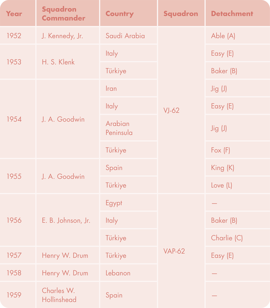
Table 2. A partial reconstruction of 1950s VJ/VAP-62 deployments and detachments (where available) in the Mediterranean, Middle East, and Türkiye. (Squadron Commander information after Grossnick 1995, 316; other information from US National Archives).
THE CONVERGENCE OF CARTOGRAPHIC AND COMMERCIAL IMPERIALISM IN US-LED EXPLORATION AND INFRASTRUCTURE DEVELOPMENT
The US Navy’s mapping missions abroad clearly supported regional objectives concerning NATO security commitments, and in Türkiye and elsewhere they also introduced US commercial interests (Kuniholm 2001, 346; Grathwol and Moorhus 2009, 27). Rankin (2016, 5) explored the general trends of the time and how “American programs of dollar diplomacy, cultural universalism, and Cold War containment . . . [shared] space with the ambitions of multinational oil companies, collaborations among European scientists, and regional surveying projects.” While Daniel Immerwahr (2019) saw similar phenomena as leading to the establishment of a “pointillist” American empire, evoking also ideas of commercial imperialism, Barney (2014, 158–159) more explicitly makes the connection to mapping, whereby “. . . cartography was posited as a facilitating force for global development that could aid security and economic ideologies.” Such linkages between security, resource exploration, infrastructure development, and US imperializing mapping initiatives are hardly surprising, as they date back to the US Navy’s earliest attainment of aerial photographic capabilities (Campbell 2014). In the context of postwar realignment, however, the intensity and widespread nature of these associations are notable.
The US Navy’s mapping projects and US commercial beneficiaries in late 1940s and early 1950s Saudi Arabia are a good example. There, in connection to airfield construction by the US Army Corps of Engineers at and around what was then the US-built and leased Dhahran Air Field (present-day King Abdulaziz Air Base) (Grathwol and Moorhus 2009) and in connection to the nearby oil explorations of majority-US-owned Aramco (Immerwahr 2019), VJ-62’s Able (A) Detachment of five officers, 24 enlisted men, and one Liberator aircraft flew numerous cartographic missions in late 1952 (Grossnick 1995, 314). Between September and December of that year alone, the squadron logged 600 nautical-mile (1,111 km) round trips each day, totaling more than 16,000 km and 584 hours of flight (Naval Aviation News 1953). The oil-reserve potential of Dhahran, along with its strategic location for Soviet containment, was clearly worth this effort.
For Türkiye, the Truman Doctrine (1947), US Marshall Plan (1948), Point Four program (1949), and membership in NATO (1952), had already infused significant funds, in addition to the equipment and expertise described above; these policies of economic support extended to development of agriculture, industry, and infrastructure based on Türkiye’s perceived “vitally strategic” nature in containing Soviet advances (U.S. Department of State 1949, 1; Hall 1999–2000, 67; Kuniholm 2001, 341–347; Atmaca 2014; Adalet 2018, 5; Luke 2019, 82–99). Türkiye’s hope that its openness to reforms and contributions to defensive alliances would be matched by increased international support bore fruit (Simpson 1965, 142; Guvenc and Uyar 2022, 71). Significant US appropriations arrived through the Joint American Military Mission for Aid to Turkey (JAMMAT), and later the Joint US Military Mission for Aid to Turkey, and went directly to the Turkish Armed Forces; yet US companies increasingly won contracts to work on Turkish development projects. Contracts awarded by the US Department of State on generous terms and administered by the US Army Corps of Engineers funded, among other things, construction-equipment training for use in numerous projects (Grathwol and Moorhus 2009, 10–17). The detrimental effect of poor communication networks on defense was eventually acknowledged in Türkiye (Guvenc and Uyar 2022, 67; 72), leading to a cooperation between the Turkish Ministry of Public Works and the US Public Roads Administration (Kerwin 1950, 196–198; Karpat 1972; Livingston 1994; Adalet 2018). Improved roads would serve not just military but agricultural and industrial economic needs, too (Üstün 1997, 45).
Between 1950–1953 additional US support was allocated to the maintenance and construction of airfields, including existing facilities—at Bandırma, Erzincan, Balıkesir, Afyon, Kayseri, and Merzifon—as well as new ones in Diyarbakır, Eskişehir, and most importantly at İncirlik, Adana, all undertaken by Metcalf-Hamilton-Grove (an American joint venture) under the supervision of The United States Engineer Group, then based in Ankara, and part of the JAMMAT structure (Livingston 1994, 805; Grathwol and Moorhus 2009, 19–24). All told, this work resulted in the construction of two new bases and the rehabilitation of five existing ones, as well as work on fuel storage and distribution systems (Grathwol and Moorhus 2009, 26, 86).
Eisenhower’s inauguration and Stalin’s death in early 1953 brought new uncertainties for regional security, and a “New Approach” was developed for the Supreme Headquarters Allied Powers Europe (NATO 1976, vii–viii). One major component of the new plans, circulated in November 1953 and eventually approved in December 1954, concerned logistics and required the improvement or new development and safeguarding of lines of communication, port and storage facilities, and airfields that were deemed insufficient to the task of stopping a Soviet advance (NATO 1976, 23–24; 36–42; 69; 82). These projects included airfields in Bursa (Yenişehir), Adana, Manisa, and Erzurum; petrol, oil, and lubricant facilities to serve such airfields (e.g., storage and pipelines); VHF communication systems where topography allowed; and naval stations at Iskenderun in the northeastern Mediterranean, Marmaris and Izmir along the Aegean, and in the Black Sea (NATO 1953).
Development projects similar to these, as well as related cartographic missions of the US Navy, undoubtedly continued into the later 1950s, as suggested by VAP-62’s large-scale imaging objective of 1957, focusing on the Cumaovası airfield in Izmir (Figures 3–4). Eventually, the US gave more than $5 billion in loans and grants to Türkiye between 1947 and 1968 for projects relating to industry and infrastructure, especially water-related infrastructure for hydropower, domestic water supply, and agricultural irrigation (Taylor 1976, 99–100; Luke 2019, 99–106). With Iran’s (short-lived) nationalization of Anglo-Iranian Oil Company oil refineries at Abadan in 1953 and Egypt’s nationalization of the Suez Canal in 1956 etched in recent memory (e.g., Luke and Leeson 2022), Türkiye’s significance in preserving US military and commercial accesses to the Middle East and points further afield was likely never overlooked (Atmaca 2014, 21–25).
CONCLUSIONS
The US Navy’s VAP-62 squadron continued working around the Atlantic for more than a decade following the last 1957 flights over Türkiye recorded in the current collection. By 1969, other priorities and squadron classifications had arisen, and VAP-62 was disestablished (Jax Air News 1969; Grossnick 1995, 314), its aircraft and crew reassigned or repurposed elsewhere. Already by the mid-1950s, US aerial photographic aims in and around Türkiye began to shift away from broad cartographic survey to tactical and intelligence-oriented imaging, a flexibility enabled by the establishment of the Türkiye-US Military Facilities Agreement signed in 1954 (Atmaca 2014, 27). As Dino Brugioni carefully outlines, it was from Türkiye, among other countries, that the US Central Intelligence Agency ordered the launch of Genetrix spy balloons in 1956, the same year it established the Incirlik Airfield in Adana as a base for U-2 operations, with its own Overseas Photo Interpretation Center (2010, 34–47; 140–147; 176–178; 270). In 1959 it was decided to place Jupiter missiles at Incirlik; in 1960 Gary Powers’ made his ill-fated U-2 flight; and the ensuing history of events is well known by now.
Still comparatively poorly known are the US Navy’s aerial surveys described above, and the imagery archive they left behind. The images in this archival collection, curated in the General Directorate of Mapping (and before that, the General Command of Mapping) of the Republic of Türkiye’s Ministry of National Defense, as well as at least partially in the US National Archives, demonstrate the mutual interests that were served by the “special agreements” made between the US and peer NATO members. For Türkiye, “an agreement relating to mutual security” (UN 1954, 6 no. 2361) had already been established with the US on January 7, 1952, just before it joined NATO, tacitly paving the way for continuingly close collaborations (e.g., Budek 1956, 398–399; 440–441).
Following Türkiye’s accession to NATO on 18 February 1952, it collaborated with the US Navy on this cartographic project over at least five years, and perhaps longer. Improved maps meant improved security planning and related infrastructure development. US dollars supported US agencies and contractors which not only participated in the work but also trained Turkish personnel to do the same. The intertwined NATO security and development projects, thus, were convincingly promulgated, with both Turkish and American benefits. That new American standards of cartographic practice and the power relationships they underlay were accepted in Türkiye in return for security guarantees, accurate documentation of Anatolian topography, understandings of economic geography, and improved regional communications is unsurprising. Similar symbiotic arrangements clearly pertained in other NATO-member circum-Mediterranean countries situated with strategic value for Soviet containment. What other seemingly mutual benefits may have been included in the arrangements that governed this work will have to await elucidation in future research.
ACKNOWLEDGEMENTS
This research would not have been possible without helpful assistance from colleagues at the General Directorate of Mapping, Ministry of Defense, Republic of Türkiye, and Koç University’s former and current official liaisons with them, Ramazan Kalaycı, Bekir Yazıcı, and Samet Sönmez. For assistance in locating relevant textual and photographic archives in US collections, I would like to thank members of both the Cartographic Branch (Corbin Apkin, Amy Edwards, Ryan McPherson, and colleagues) and the Textual Reference Branch (Nathanial Patch) of the US National Archives at College Park, MD (Archives II), as well as Michael Rhodes of the US Naval History and Heritage Command. I am grateful to Koç University’s Research Center for Anatolian Civilizations (ANAMED) for funding and research support and to Duygu Tarkan for managing the acquisition of ANAMED’s current holdings and helpful feedback. Xin Hong, Hilal Küntüz, and Emre Yurttaş helped collate some of the camera-printed label data and have my thanks. For helpful comments on previous drafts, I would like to thank Christina Luke, as well as Jim Thatcher, Daniel Huffman, and anonymous reviewers, all of whose extremely constructive feedback has—I hope—led to a more cogent end product. All errors in data and interpretation of course remain my own.
REFERENCES
Adalet, Begüm. 2018. Hotels and Highways: The Construction of Modernization Theory in Cold War Turkey. Stanford Studies in Middle Eastern and Islamic Societies and Cultures. Stanford, CA: Stanford University Press.
Atmaca, Ayşe Ömür. 2014. “The Geopolitical Origins of Turkish-American Relations: Revisiting the Cold War Years.” All Azimuth: A Journal of Foreign Policy and Peace 3 (1): 19–34. https://doi.org/10.20991/allazimuth.167319.
Babington-Smith, Constance. 1957. Air Spy: The Story of Photo Intelligence in World War II. New York: Harper.
Barney, Timothy. 2014. Mapping the Cold War: Cartography and the Framing of America’s International Power. Chapel Hill, NC: University of North Carolina Press.
Brookes, Andrew J. 1975. Photo Reconnaissance. London: Ian Allen.
Brugioni, Dino A. 2010. Eyes in the Sky: Eisenhower, the CIA, and Cold War Aerial Espionage. Annapolis, MD: Naval Institute Press.
Budek, Mieczyslaw. 1956. “Turkish Commercial Aviation.” Journal of Air Law and Commerce 23 (4): 379–478.
Campbell, Douglas E. 2014. Flight, Camera, Action! The History of U.S. Naval Aviation Photography and Photo-Reconnaissance. Washington, DC: Syneca Research Group, Inc.
Cahill, William M. 2012. “Imaging the Empire: the 3rd Photographic Reconnaissance Squadron in World War II.” Air Power History 59 (1): 12–19.
Chase, Joseph, Louis J. Cote, Wilbur Marks, Emanuel Mehr, Willard J. Pierson, Jr., F. Claude Rönne, George Stephenson, Richard C. Vetter, and Robert G. Walden. 1957. The Directional Spectrum of a Wind Generated Sea as Determined from Data Obtained by the Stereo Wave Observation Project. Technical report prepared for the Office of Naval Research under Contract NONR 285(03). New York: New York University. https://doi.org/10.5962/bhl.title.39092.
Chourchoulis, Dionysios. 2009. “High Hopes, Bold Aims, Limited Results: Britain and the Establishment of the NATO Mediterranean Command, 1950–1953.” Diplomacy & Statecraft 20 (3): 434–452. https://doi.org/10.1080/09592290903293779.
———. 2012. “A nominal defence? NATO threat perception and responses in the Balkan area, 1951–1967” Cold War History 12 (4): 637–657. https://doi.org/10.1080/14682745.2012.671297.
———. 2015. The Southern Flank of NATO, 1951–1959: Military Strategy or Political Stabilization. Lanham, MD: Lexington Books.
Clarke, Keith C., and John G. Cloud. 2000. “On the Origins of Analytical Cartography.” Cartography and Geographic Information Science 27 (3): 195–204. https://www.doi.org/10.1559/152304000783547821.
Cloud, John. 2001. “Imaging the World in a Barrel: CORONA and the Clandestine Convergence of the Earth Sciences.” Social Studies of Science 31 (2): 231–251. https://doi.org/10.1177/0306312701031002005.
———. 2002. “American Cartographic Transformations during the Cold War.” Cartography and Geographic Information Science 29 (3): 261–282. https://doi.org/10.1559/152304002782008422.
Cloud, John G., and Keith C. Clark. 1999. “Through a Shutter Darkly: The Tangled Relationships Between Civilian, Military and Intelligence Remote Sensing in the Early U.S. Space Program.” In Secrecy and Knowledge Production, edited by Judith Reppy, 36–56. Cornell University Peace Studies Program, Occasional Paper 23. Ithaca, NY: Cornell University Peace Studies Program.
Cosgrove, Denis. 2001. Apollo’s Eye: A Cartographic Genealogy of the Earth in the Western Imagination. Baltimore: Johns Hopkins University Press.
———. 2008. Geography and Vision: Seeing, Imagining, and Representing the World. London: I. B. Tauris & Co. Ltd.
Cosgrove, Denis, and William L. Fox. 2010. Photography and Flight. London: Reaktion Books.
Cossaboom, Robert, and Gary Leiser. 1998. “Adana Station 1943–45: Prelude to the Post‐war American Military Presence in Turkey.” Middle Eastern Studies 34 (1): 73–86. https://doi.org/10.1080/00263209808701210.
van Creveld, Martin. 1991. Technology and War: From 2000 B.C. to the Present. New York: Free Press.
———. 2011. The Age of Airpower. New York: Public Affairs.
Daston, Lorraine, and Peter Galison. 2007. Objectivity. New York: Zone Books.
De Landa, Manuel. 1991. War in the Age of Intelligent Machines. Cambridge, MA: MIT Press.
DeForge, Gerald T. 1981. Navy Photographer’s Mate Training Series: Naval Photography. Module 1. Naval Photography. Pensacola, FL: Naval Education and Training Command; Naval Education and Training Program Development Center.
Doeppers, Daniel F. 1972. “An Incident in the PRRI/Permesta Rebellion of 1958.” Indonesia 14: 182–195. https://doi.org/10.2307/3350738.
Dyce, Matt. 2013. “Canada between the photograph and the map: Aerial photography, geographical vision and the state.” Journal of Historical Geography 39: 69–84. https://doi.org/10.1016/j.jhg.2012.07.002.
Edney, Matthew H. 2014. “Academic Cartography, Internal Map History, and the Critical Study of Mapping Processes.” Imago Mundi 66 (1): 83–106. https://doi.org/10.1080/03085694.2014.947853.
El Hassan, Ismat Mohamed. 1978. “Metric Aspects of Reconnaissance Frame Photography.” Ph.D. diss., University of Glasgow.
Erbaş, Mehmet. 2013. “Hava Fotoğrafı Arşivi Bilgi Sistemi [Aerial Photograph Archive Information System].” Harita Dergisi 150: 28–34.
Ertung, Özcan. 1970. “Hava Fotoğrafçılığının Öncüleri.” Harita Dergisi 74: 81–90.
Evinay, Kerim. 1956 “Havadan Fotoğraf Alımı.” Harita Dergisi 53: 13–68.
Ginter, Steve. 1992. North American AJ-1 Savage (Naval Fighters Number 22). Simi Valley, CA: Steve Ginter.
Goddard, George W., with Dewitt S. Copp. 1969. Overview: A Life-Long Adventure in Aerial Photography. Garden City, NY: Doubleday and Co.
Godlewska, Anne. 1989. “Traditions, Crises, and the New Paradigms in the Rise of the Modern French Discipline of Geography 1760–1850.” Annals of the Association of American Geographers 27 (2): 192–213.
Grathwol, Robert P., and Donita M. Moorhus. 2009. Bricks, Sand, and Marble. U.S. Army Corps of Engineers Construction in the Mediterranean and Middle East, 1947–1991. Washington, DC: US Army Center of Military History and Corps of Engineers.
Grossnick, Roy A. 1995. Dictionary of American Naval Aviation Squadrons, Volume I: The History of VA, VAH, VAK, VAL, VAP and VFA Squadrons. Washington, DC: Naval Historical Center.
Guvenc, Serhat, and Mesut Uyar. 2022. “Lost in Translation or Transformation? The Impact of American Aid on the Turkish Military, 1947–60.” Cold War History 22 (1): 59–77. https://doi.org/10.1080/14682745.2020.1866551.
Haffner, Jeanne. 2013. The View from Above: The Science of Social Space. Cambridge, MA: MIT Press. https://doi.org/10.7551/mitpress/7878.001.0001.
Hall, R. Cargill. 1999–2000. “From Concept to National Policy: Strategic Reconnaissance in the Cold War.” American Intelligence Journal 19 (3/4): 63–75.
Harley, J. B. 2001a. “Maps, Knowledge, and Power.” In The New Nature of Maps: Essays in the History of Cartography, edited by Paul Laxton, 51–81. Baltimore: Johns Hopkins University Press.
———. 2001b. “Silences and secrecy.” In The New Nature of Maps: Essays in the History of Cartography, edited by Paul Laxton, 83–107. Baltimore: Johns Hopkins University Press.
Heiman, Grover. 1972. Aerial Photography: The Story of Aerial Mapping and Reconnaissance. New York: The Macmillan Co.
HGM Hava Fotoğrafı. 2023. “Analog Kamerayla Çekilmiş Hava Fotoğrafı.” Harita Genel Müdürlüğü. Accessed March 3, 2023. https://www.harita.gov.tr/urun/analog-kamerayla-cekilmis-hava-fotografi/161.
Hong, Xin, and Christopher H. Roosevelt. 2023. “Orthorectification of Large Datasets of Multi‐scale Archival Aerial Imagery: A Case Study from Türkiye.” Journal of Geovisualization and Spatial Analysis 7: 23. https://doi.org/10.1007/s41651-023-00153-1.
Immerwahr, Daniel. 2019. How to Hide an Empire: A History of the Greater United States. New York: Farra, Straus and Giroux.
Jax Air News. 1952. “Photo Squadron 62 Commissioned Here.” Jax Air News 10 (2). April 10, 1952.
———. 1969. “VAP-62 and VP-7 Slated for Decommissioning.” Jax Air News 27 (27). September 25, 1969.
Kanbay, C. 1938. “Fotoğrametri ve Havadan Alınımış Fotoğraflardan Topoğrafların İstifadesi.” Harita Dergisi 20: 30–33.
Kaplan, Caren. 2018. Aerial Aftermaths: Wartime from Above. Durham, NC: Duke University Press. https://doi.org/10.1215/9780822372219.
Karpat, Kemal H. 1972. “Political Developments in Turkey, 1950-70.” Middle Eastern Studies 8 (3): 349–375.
Kerwin, Robert W. 1950. “The Turkish Roads Program.” Middle East Journal 4 (2): 196–208. http://www.jstor.org/stable/4322166.
Kumral, Mehmet Akif. 2020. “The Affective Atmosphere of Ankara-Tehran Alignment in Cold War (1946–1979).” In Exploring Emotions in Turkey-Iran Relations, by Mehmet Akif Kumral, 119–182. Cham, CH: Springer International Publishing. https://doi.org/10.1007/978-3-030-39029-7_3.
Kuniholm, Bruce. 2001. “The Evolving Strategic Significance of Turkey’s Relationship with NATO.” In A History of NATO: The First Fifty Years, edited by Gustav Schmidt, 339–357. London: Palgrave Macmillan. https://doi.org/10.1007/978-1-349-65573-1_20.
Lieber, Albert C. 1954. “International Cooperation in Mapping.” Surveying and Mapping 14: 71–74.
Livingston, Craig. 1994. “‘One Thousand Wings’: The United States Air Force Group and the American Mission for Aid to Turkey, 1947–50.” Middle Eastern Studies 30 (4): 778–825. http://www.jstor.org/stable/4283676.
Luke, Christina. 2019. A Pearl in Peril: Heritage and Diplomacy in Turkey. Oxford: Oxford University Press. https://doi.org/10.1093/oso/9780190498870.001.0001.
Luke, Christina, and Madison Leeson. 2022. “UNESCO-UNDP Tourism and Security in Cold War Turkey and Iran. Journal of Heritage Tourism. 17 (6): 669–684. https://doi.org/10.1080/1743873X.2022.2096457.
Mahan, John H. 2003. “‘EVERY MAN A TIGER’: The RF-86A Sabre in Tactical Reconnaissance Operations during the Korean War, 1952–1953.” Air Power History 50 (4): 30–37.
NAO. 1956. Naval Aeronautical Organization OPNAV NOTICE 05400 for Fiscal Year 1957 dated 20 November 1956.
———. 1958. Naval Aeronautical Organization OPNAV NOTICE 05400 for Fiscal Year 1959 dated 8 October 1958.
NATO. 1953. Report by the Logistic and Materiel Planners to the Standing Group on the 1954 Common Infrastructure Program. NATO Unclassified Archives. 1953-SG_173_32.
———. 1976. History. Supreme Headquarters Allied Powers Europe. The New Approach, 1953–1956. NATO Unclassified Archives. 3340/11-3/S/11/76.
Naval Aviation News. 1953. “Med Photo Plane Keeps Active.” Naval Aviation News July 1953, 26.
———. 1953c. “‘Glass Eyes’ Map Secrets Of Enemy.” Naval Aviation News December 1953, 9–11.
———. 1954. “AJ-2P Sets A New Record: VJ-62 Plane Piles Up Flight Time.” Naval Aviation News January 1954, 14.
———. 1955. “Army Praises VJ-62 Work: Maps Greenland Ice for Engineers.” Naval Aviation News April 1955, 18.
———. 1956a. “The World is their Camera Beat.” Naval Aviation News January 1956, 31.
———. 1956b. “Photo Squadrons Re-Named: VCs and VJ’s are Re-designated.” Naval Aviation News August 1956, 14.
———. 1956c. “Ice Floes Ahead! Ships and Supplies Get through to Arctic Outposts Guided by Ice Forecasts Put Out by U.S. Navy Hydrographic Office.” Naval Aviation News October 1956, 1–5.
———. 1958a. “VAP-62 Gets New Plane: Photo Skywarrior Arrives at JAX.” Naval Aviation News January 1958, 36.
———. 1958b. “Clouds, Carbon and Change.” Naval Aviation News October 1958, 20–23.
———. 1958c. “Cameras Are Their Weapons.” Naval Aviation News November 1958, 7–12.
NTPC. 1962. Photographer’s Mate 2. Navy Training Course. NavPers 10374-A. Instructional Standards of Materials Division of the Bureau of Naval Personnel. Memphis, TN: US Navy Training Publications Center.
Önder, Mustafa. 2002. Geçmişten Günümüze Resimlerle Türk Haritacılığı / From Past to Present: The Illustrated History of Turkish Cartography. Ankara: Harita Genel Komutanlığı.
Rankin, William. 2016. After the Map: Cartography, Navigation, and the Transformation of Territory in the Twentieth Century. Chicago, IL: University of Chicago Press. https://doi.org/10.7208/chicago/9780226339535.001.0001.
Redweik, Paula, D. Roque, A. Marques, R. Matildes, and F. Marques. 2010. “Triangulating the Past – Recovering Portugal’s Aerial Images Repository.” Photogrammetric Engineering & Remote Sensing 76 (9): 1007–1018. https://doi.org/10.14358/PERS.76.9.1007.
Rose, Leslie. 2007. Power at Sea. Volume 3: A Violent Peace, 1945–2000. Columbia, MO: Missouri University Press.
Saint-Amour, Paul K. 2011. “Applied Modernism: Military and Civilian Uses of the Aerial Photomosaic.” Theory, Culture and Society 28 (7–8): 241–269. https://doi.org/10.1177/0263276411423938.
Schuster, Carl O. 2016. “Capturing Enemy Territory on Film.” Vietnam 29 (1): 22.
Sekula, Allan. 1984. Photography against the Grain: Essays and Photo Works, 1973–1983. Halifax: Press of the Nova Scotia College of Art and Design.
Sichel, Kim. 2007. To Fly: Contemporary Aerial Photography. Seattle: University of Washington Press.
Simpson, Dwight J. 1965. “Development as a Process: The Menderes Phase in Turkey.” The Middle East Journal 19 (2): 141–52. http://www.jstor.org/stable/4323847.
Sokolsky, Joel. 1991. Seapower in the Nuclear Age. The United States Navy and NATO 1949–80. London: Routledge.
Taylor, George, C., Jr. 1976. Historical Review of the International Water-Resources Program of the U.S. Geological Survey 1940–70. Geological Survey Professional Paper 911. Washington, DC: United States Government Printing Office. https://doi.org/10.3133/pp911.
Thomas, Geoffrey J. 1999. Eyes for the Phoenix: Allied Aerial Photo-Reconnaissance Operations in South-East Asia 1942–1945. Hants, UK: Hikoki Publications.
Truesdell, P. E. 1953. “Report of unclassified military terrain studies section.” Photogrammetric Engineering 19 (3): 468–472.
UN. 1954. “International Agreement No. 2361.” Statement of Treaties and International Agreements Registered or Filed and Recorded with the Secretariat during November 1953. ST/LEG/SER.A/Sl, 6.
Üstün, Senem. 1997. “Turkey and the Marshall Plan: Strive for Aid.” Turkish Year Book of International Relations 27: 31–52. https://doi.org/10.1501/Intrel_0000000254.
U.S. Department of State. 1949. Policy Statement. Washington DC, May 5, 1949.
U.S. Navy Patrol Squadrons. 2024a. “VAP-62 History.” Accessed May 16, 2024. https://www.vpnavy.org/vap62_history.html.
———. 2024b. “VJ-62 History.” Accessed May 16, 2024. https://www.vpnavy.org/vj62_history.html.
Virilio, Paul. 1989. War and Cinema: The Logistics of Perception. London: Verso.
Weidick, Anker. 1958. “Frontal Variations at Upernaviks Isstrøm in the Last 100 Years.” Meddelelser fra Dansk Geologisk Forening 14 (1): 52–60.
Wood, Denis, and John Fels. 1992. The Power of Maps. New York: Guilford Press.