DOI: 10.14714/CP105.1985
© by the author(s). This work is licensed under the Creative Commons Attribution-NonCommercial-NoDerivatives 4.0 International License. To view a copy of this license, visit http://creativecommons.org/licenses/by-nc-nd/4.0.
A Discussion on the Ethics of Mapping Place Names for Riverine Forests in Tana River, Kenya
Laura C. Loyola (she/her), University of Southern California | loyola@usc.edu
Julie Wieczkowski (she/her), SUNY Buffalo State University | wieczkja@buffalostate.edu
Rose Abae (she/her), Wildlife Research and Training Institute | roseabae@gmail.com
Lara Allen, Centre for Global Equality | lara.allen@centreforglobalequality.org
Stanislaus Kivai, Kenya Institute of Primate Research | skivai@primateresearch.org
Susan Tang, University of Southern California | susantan@usc.edu
Leyna Tran, University of Southern California | leynatra@usc.edu
We are an international group of researchers and conservationists with expertise in biological anthropology, environmental studies, international development, spatial sciences, and community-centered conservation. With over thirty years of combined research and lived experience in the Tana River region of Kenya, local place names for forests and woodlands have been shared with us through personal interactions, participatory mapping workshops, and other community workshops. We present an ongoing discussion about the ethics of publishing local names of sections of riverine forest patches and other locales, especially without inter- and intra-community agreement on these names. This conversation is especially critical for sustainable forest resource utilization, human-wildlife conflict, and biodiversity conservation. We present cartographic options and spatial analysis methods to reconcile the already-published names with the locally-named places and to preserve the privacy of villagers’ activities. Also important are the implications for land ownership, rights, and control that claiming place names may have in this region at this time in history as land rights are presently being negotiated between different ethnic groups and clans. We explore a potential for harmonizing a naming system built upon consensus within the many invested Kenyan communities and anchored in their traditional way of naming places. We acknowledge that an ethical approach would be to publish names used by local people, but this is complicated by lack of local consensus.
KEYWORDS: place names; generalized point locations; cartographic solutions; ethical mapping; sustainable resource use
THE ISSUE
We are an international group of researchers and conservationists with expertise in biological anthropology, environmental studies, international development, spatial sciences, and community-centered conservation. One of the authors (Abae) on this paper is from the county of Tana River in Kenya, while the other (Kivai) is from the neighboring county of Makueni, both in the southeast of the country. Three of the US- and UK-based researchers (Loyola, Wieczkowski, and Allen) have spent months, even years, living in research camps in the Tana riverine forests or nearby villages. Two of the authors (Tang and Tran) are current undergraduate student researchers working with Loyola through the University of Southern California’s Undergraduate Research Assistantship Program (URAP). The five senior researchers have knowledge of local names of sections of riverine forest patches and associated locales, acquired through lived experience, personal interactions, and numerous community workshops. However, we face an ethical conundrum on how to reconcile the published names of the riverine forests (Andrews et al. 1975; Marsh 1976, 1986; Medley 1993; Butynski and Mwangi 1994; Decker 1994; Wieczkowski and Mbora 2000; Moinde-Fockler et al. 2007; Kivai et al. 2021; Kivai et al. 2023) with these local names. This deliberation is especially critical, given the implications for land rights that claiming place names may have in this area at this time in history, as land rights are presently being negotiated between different ethnic groups (mainly the Pokomo and Wardei, though there are others) and clans. Our question is whether it is ethical to publish local names.
The ethical issue that arises is whether it is acceptable to publish one set of names without a thorough discussion with all invested groups, particularly knowing that reaching a consensus may not be possible. In the Tana River region, as in many other locations, place names are often related to claims of ownership, rights to land use, ancestral attachment, and other aspects of land management (e.g., Boillat et al. 2013; Gray and Rück 2019; Hercus and Simpson 2002; Rose-Redwood 2021). Place names may also carry different meanings and information for different people and communities. These names may have been passed down through generations or they may have a more recent origin. In Tana River, the contentious nature of land ownership, rights, control, and naming surfaces even at the sub-forest spatial scale. It is also at this spatial scale that forest product utilization and conservation occur. It is therefore important to examine the ethics not only at the larger spatial scale recognized by international researchers, but also at the smaller spatial scale that the local people inhabit. The citing of more locally-recognized place names risks becoming a lightning rod for the above tensions because naming is claiming. Is it ethical for us to make a decision that exacerbates these tensions just by publishing one name (in one language or dialect or from one source) rather than another? In this paper, in order to discuss the question of naming within forests, we refer to these larger forests and woodlands as forest patches, and we refer to smaller areas within the forest patches as forest sections.
There are approximately 70 to 75 forest patches along the lower Tana River in southeastern Kenya (Figure 1). These forest patches grow and shrink over the decades, due to both natural and anthropogenic factors. In addition, they are extremely heterogeneous in plant species composition (Hughes 1988, 1990). These forest patches are of international conservation concern and are part of the Coastal Forests of Eastern Africa biodiversity hotspot, a region of high species diversity with many endemic and endangered species (Myers et al. 2000). They are home to two endemic non-human primates: the Tana River red colobus (Piliocolobus rufomitratus) and the Tana River mangabey (Cercocebus galeritus). Both primates are classified as Critically Endangered. These forests are also classified as an Important Bird Area by BirdLife International. The primates are offered some protection in the Tana River Primate National Reserve, which is in the northern half of the species’ ranges.
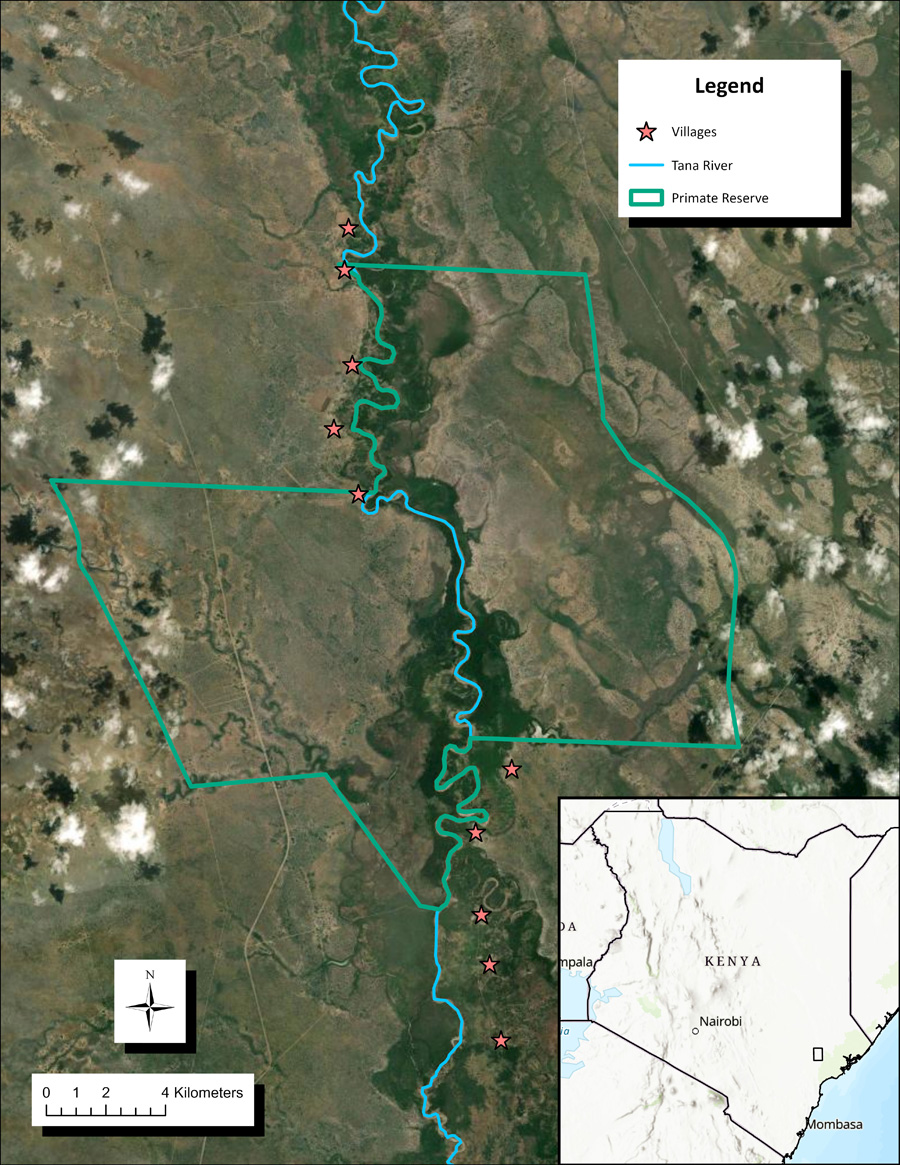
Figure 1. The area of interest is in the lower Tana River region, shown by the rectangle in the inset map. Selected village locations (shown with red stars), the Tana River Primate National Reserve (TRPNR) boundary (shown with a green line), and the Tana River (shown in blue) are depicted over recent satellite imagery. Map created by Susan Tang.
The first ecological survey of the lower Tana River was undertaken in 1972. In the published results (Andrews et al. 1975), the majority of the 26 forests and woodlands surveyed were named after the closest villages (e.g., Wema, Wenje, Mnazini). Subsequent surveys of the lower Tana River (Marsh 1976, 1986; Butynski and Mwangi 1994; Kivai et al. 2021; Kivai et al. 2023) continued the habit of naming the majority of forests after the nearest village. Naming systems included indicating the location of such forests relative to the river (such that the forests on the west and east banks closest to Mchelelo village were called Mchelelo West and Mchelelo East); their location relative to each other (e.g., Mnazini North and Mnazini South); or with numbers (e.g., Wenje 1 and Wenje 2). Subsequent researchers (Medley 1993; Decker 1994; Wieczkowski and Mbora 2000; Moinde-Fockler et al. 2007) continued to use these published names in their work.
The discrepancy between published names and local names came to light during participatory workshops that Allen, Loyola, Wieczkowski, and our colleague David Mbora ran in 2011 in every village immediately surrounding the Tana River Primate National Reserve (see Figure 1). One aim of these workshops was to gain a better understanding of how forest resources were utilized and conserved; another was to engage community members in participatory mapping sessions to visualize their villages and surrounding areas. We asked workshop participants to list forest products that they used and to identify the locations of harvesting. The place names used for these harvesting locations were new to us, largely because the workshop participants identified smaller, more specific sections within the larger forests patches that had been named in the literature by international researchers. A similar situation arose more recently with the 2021 community pre-census survey workshops conducted by Kivai and Abae (Kivai et al. 2021). When local community administrators along the lower Tana River were asked to list forest patches in their jurisdiction, names that were different from the published data again emerged. Additionally, pastoralists and agriculturalists who live in this region have cited different names (in their own languages and dialects) for the same forest sections during our interactions with them. These people have a unique connection to the area and land, and have lived adjacent to or in the conservation area in the Tana River floodplain for hundreds of years, depending on the river’s flooding regimes and the resources that the riverine forests provide. To date, their knowledge has been transmitted largely through oral traditions; therefore, the depth and richness of this expertise is ignored, or even occluded, in the published record.
We have used the commonly published forest names in our previous manuscripts. However, these community workshops have made us realize that we would better understand the Tana River forests and the communities’ interactions with the forests if we use local names to specify forest sections. Using more specific place names facilitates vegetation analysis (Valkó et al. 2023); biodiversity monitoring, mapping of resource use to determine sustainable practices, and conservation planning (Boillat et al. 2013; Gray and Rück, 2019); and prioritization of forest sections for research and conservation. Using local names also allows us to visualize the forest patches and sections as the local people do and to understand better how they interact with their environment. For example, places that are mentioned in reference to forest resource extraction, human-wildlife conflict, cultural utilization, or primary habitat for the two endemic and threatened primates are of great interest. These named sections could be located within forest patches, or they could be woodland/scrubland that is on the edge of the patches; this distinction may cause managers to take differing conservation/management actions.
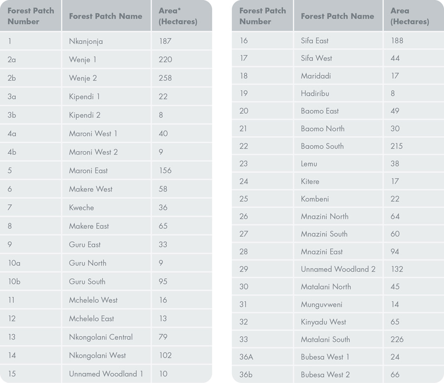
Table 1. Selected forest patches and their published names. Forest patches are identified by their numbers and corresponding published names, as well as the forest area in hectares. The table is adapted from Figure 3 in Butynski and Mwangi (1994), and it references Figure 2 below. *Areas calculated using polygon geometry in GIS software.
We have recently identified the locations of smaller forest sections within a group of larger forest patches that have been referenced by local names by two (Pokomo and Wardei) of several ethnic groups in the region of the Tana River Primate National Reserve (see Table 1); these two ethnic groups are the ones with the most people living adjacent to the forests. With this knowledge, we hope to gain a better understanding of where these areas are, how they are used by local people, and which conservation/sustainability issues relate to these forest sections. There is also the potential to harmonize the naming system, especially for those areas in conflict and those that can be utilized sustainably by local villagers while conserving wildlife habitats. However, we should bear in mind the natural floodplain ecology, the meandering nature of the river, and anthropogenic factors that affect the floodplain habitat (Loyola and Delgado 2014). Hydrologic changes affecting the meanders of the Tana River may “relocate” forests and even villages to the opposite side of the river, which may affect the system of naming forests after their nearest villages and the side of the river on which they are located. Additionally, with changing climatic conditions and a variety of anthropogenic influences (such as forest clearance for farmland, modification due to small-scale forest product use, and expansion from tree nursery plantings), new forests are developing through regeneration into adjoining forest patches, while others are disappearing (see Figure 2). Native vegetation is also being replaced by invasive species. The dynamic nature of the ecosystem affects the names given to the riverine forests under the current naming conventions. Thus, if a harmonized system is established, the dynamic nature of the geographic area and its influence on place names must be considered. We would also have to incorporate a review period and produce updated visualizations from satellite imagery or ground-truthed locations as they are critical to updating the naming system.
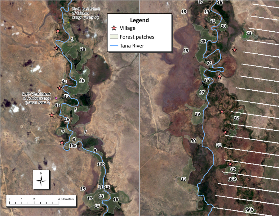
Figure 2. Selected forest patches were digitized from the original 77 forest and forest sections in Figure 4 in Butynski and Mwangi (1994). Patch numbers correlate with Table 1; 1–17 are the northern half of the range, 18–36b are in the southern half of the range. They are shown here over 2011 imagery to illustrate forest variations from the static maps published in 1994. The 1994 forest patches no longer correspond with the dark green forest areas seen in the 2011 imagery. The Tana River location was digitized from 2007 Google Earth Pro imagery. White diagonal lines are artifacts in the satellite imagery. Map created by Leyna Tran.
Unlike some research collaborations in North America in which the goal was to shed light on and share the multitude of place names for specific locations (e.g., Coming Home to Indigenous Place Names in Canada), our work has not previously focused on this issue. Several ethnic groups live in the Tana River area, and there has been a long history of ethnic conflict, especially between the agriculturalists (Pokomo) and the pastoralists (Wardei, Somali, and Orma). As names can assert or infer a sense of ownership, we understand the potential conflict that may arise when assigning the name used by researchers, one ethnic group, or even just one clan within an ethnic group, to a location without consulting others in the vicinity/locality. Because there is no consensus on these names, publishing the names that we learned in our community workshops risks advantaging at least one group over another. However, understanding the smaller forest sections associated with specific place names, as opposed to only the larger forest patches, may ultimately contribute to resolving potential human-wildlife conflict, responding quickly to emergencies, enhancing sustainable utilization of forest products, and increasing the understanding of forest and primate ecology. Therefore, we considered different options for resolving this conundrum.
POSSIBLE SOLUTIONS
One solution is to determine the exact location associated with each named place, utilize the locations for the spatial analysis, and then publicly reference specific locations using only already published forest names. However, this raises the question of who becomes the holder or keeper of the unpublished names, and at what point it is determined that the unpublished place name can or cannot be published. Alternatively, we could try to build consensus among the invested communities to establish agreed-upon place names, thereby harmonizing the naming system. These place names could then be shared with academic researchers and with the local community groups. Again, the process of sharing the place names with various types of local community groups that are not necessarily associated with clans or ethnic groups poses issues relating to the right to act as the naming adjudicator of these locales. Another option would be to locate the named places with our current knowledge and explicitly map their locations for analysis, then omit the place names from any maps or tables before publication. Depending on the research question (e.g., forest product use), we may even omit locations from publications. However, this option likely leaves future researchers and conservationists encountering the same challenges that we have.
We have discussed potential geographic and cartographic solutions that do not necessarily address the issue of place names, but that would allow us to produce maps of the results of our spatial analysis. Of the various geographic “masking techniques,” the ones that we focus on are: (1) generalizing the point locations, (2) masking them using a randomized distance/direction offset, and (3) creating uniform buffers around point locations and dissolving them after the spatial analysis is completed. Generalizing point locations provides a general impression of where the place could be, maintains data anonymity, but does not preserve relative spatial accuracy of forest section size. This approach is commonly used to anonymize health, crime, or endangered species data (Zandbergen 2014; Seidl et al. 2018). For our research, it would provide the advantage of not revealing exact locations of resources and forest sections while (somewhat) clearly showing the locations of villages and forest patches relative to each other. However, the results of this approach may be too generalized to be useful because it does not show the variation in forest patch size.
The second option is an offset that shifts the feature in a specified or randomized direction and distance such that the actual location remains unknown. An advantage is that this approach preserves the privacy of the villagers’ activities and allows for the same number of point observations to be analyzed. Another is that most masking algorithms allow for randomness in the shift of the data (Zandbergen 2014). A disadvantage is determining the best method for offsetting, including whether to select a random direction at (or within) a fixed or random distance.
Lastly, we could conduct the spatial analysis on the accurately geolocated forest sections and, upon completion, create graduated buffers and remove point locations. This provides a rough idea of where the place name relates to, but it does not reveal the exact location. An advantage is that buffers could show the relative sizes of forest patches. As a result, the general area in which human-wildlife interactions occur or where biodiversity hotspots are located can be visualized, thereby strengthening the outputs of our analysis. One challenge is finding the right buffer sizes to protect the locations of resources while remaining useful; another is the potential for the confusion that overlapping buffers may cause.
On one hand, there is a responsibility to engage in ethical cartography by avoiding the prioritization of one set of place names over another and publishing local names. On the other hand, there is an equally compelling rationale to publish accurate research results that support sustainable resource use and resolve human-wildlife conflict. These objectives are inherently contradictory, which emphasizes the complexity and difficulty of addressing this issue. The most transparent and ethical approach might be to acknowledge that there are multiple place names in use and include a disclaimer in future publications and presentations stating that we recognize that for one place name there may be other names used by different groups, as mentioned above.
In this article, we suggested some cartographic solutions for publishing our research results; however, these solutions do not address the underlying ethical issues of how power can be embodied in place names, who holds these names, and when and how these names are shared. We are currently working on publishing results of our analysis from the data collected from our 2011 workshops, so we are also trying to accurately identify locally-named places through ground-truthing and subsequent interviews. At the same time, we are weighing our options to obtain the most accurate spatial analysis, while also producing cartographically ethical maps (i.e., considering the interests of the local people in our decision to name and/or map forest sections). However, we are still unresolved as to how to do this. The ideal resolution, as it would be based on participatory mapping and with the inclusion of multiple ethnic groups and clans, would be for local groups to agree on a harmonized naming system anchored in their traditional way of naming places. This solution would enact their right to designate the names and permit others to use them. This would, however, likely require multiple stakeholder meetings within and among the local community groups over an extended period of time, which would require funding and person-power resources. Not only is this beyond the scope of our current research, but it is also a process that arguably is outside the mandate of academic researchers, as it pertains to local politics. Nonetheless, we believe it is important, and we hope this process will be possible in the future.
ACKNOWLEDGEMENTS
To many past and present field research assistants, elders of the communities, and Tana Conservation and Conservation for People, without whom the initial and continued work in the area would not be possible.
REFERENCES
Andrews, Peter, C. P. Groves, and J. F. M. Hughes. 1975. “Ecology of the Lower Tana River Flood Plain (Kenya).” Journal of the East Africa Natural History Society and National Museum 151: 1 – 31.
Boillat, Sébastien, Elvira Serrano, Stephan Risk, and Fikret Berkes. 2013. “The Importance of Place Names in the Search for Ecosystem-Like Concepts in Indigenous Societies: An Example from the Bolivian Andes” Environmental Management 51: 663–678. https://doi.org/10.1007/s00267-012-9969-4
Butynski, Thomas M., and Geoffrey Mwangi. 1994. “Conservation Status and Distribution of the Tana River Red Colobus and Crested Mangabey.” Report for Zoo Atlanta, Kenya Wildlife Service, National Museums of Kenya, Institute of Primate Research, and East African Wildlife Society. https://coastalforests.tfcg.org/pubs/Tana_Colobus_Mangabey.pdf.
Decker, Barbara Sigman. 1994. “Effects of Habitat Disturbance on the Behavioral Ecology and Demographics of the Tana River Red Colobus (Colobus badius rufomitratus).” International Journal of Primatology 15 (5): 703–737. https://doi.org/10.1007/bf02737428.
Gray, Christina and Daniel Rück. 2019. “Reclaiming Indigenous Place Names.” Yellowhead Institute. Policy Brief 40. October 7, 2019. https://yellowheadinstitute.org/2019/10/08/reclaiming-indigenous-place-names/.
Hughes, Francine M. R. 1988. “The Ecology of African Floodplain Forests in Semi-Arid and Arid Zones: A Review.” Journal of Biogeography 15: 127–140. https://doi.org/10.2307/2845053.
———. 1990. “The Influence of Flooding Regimes on Forest Distribution and Composition in the Tana River Floodplain, Kenya.” Journal of Applied Ecology 27 (2): 475–491. https://doi.org/10.2307/2404295.
Hercus, Luise, and Jane Simpson. 2002. “Indigenous Place Names: An Introduction.” In The Land is a Map: Placenames of Indigenous origin in Australia, edited by Luise Hercus, Flavia Hodges, and Jane Simpson, 1–23. Canberra, Australia: Pandanus Books.
Kivai, Stan, B. Kuloba, Charles M. Kivasu, and Peter N. Fundi. 2021. “The Population Status of the Endangered Tana River Primates.” In National Wildlife Census 2021 Report, 93–94. Kenya Wildlife Service, and Wildlife Research & Training Institute.
Kivai, Stan, Rose Abae, P. M. Kabasa, T. Wambua, J. W. Mbugua, and P. M. Otoli. 2023. “Primate Population Survey in Block B (Mitapani to Mwina Forest patches) in the Lower Tana River Gallery Forests, Kenya.” Primate Survey Report, Kenya Institute of Primate Research.
Loyola, Laura C. and Roberto Andres Delgado. 2014. “Surviving in the Tana: Behavioral ecology and conservation of the Tana River red colobus (Procolobus rufomitratus).” Joint Meeting of the International Primatological Society and American Society of Primatologists. Hanoi, Vietnam.
Marsh, Clive W. 1976. “A Management Plan for the Tana River Game Reserve, Kenya.” Report for the New York Zoological Society and University of Bristol.
———. 1986. “A Resurvey of Tana River Primates and Their Habitat.” Primate Conservation 7: 72–82.
Medley, Kimberly E. 1993. “Primate Conservation Along the Tana River, Kenya: An Examination of the Forest Habitat.” Conservation Biology 7 (1): 109–121. https://doi.org/10.1046/j.1523-1739.1993.07010109.x.
Moinde-Fockler, Nancy Nthenya, Nicholas Otienoh Oguge, Genesio Mugambi Karere, Daniel Otina, and Mbaruk Abdalla Suleman. 2007. “Human and Natural Impacts on Forests Along Lower Tana River, Kenya: Implications Towards Conservation and Management of Endemic Primate Species and Their Habitat.” Biodiversity and Conservation 16: 1161–1173. https://doi.org/10.1007/s10531-006-9096-8.
Myers, Norman, Russell A. Mittermeier, Cristina G. Mittermeier, Gustavo A. B. da Fonseca, and Jennifer Kent. 2000. “Biodiversity hotspots for conservation priorities.” Nature 403: 853–858. https://doi.org/10.1038/35002501.
Rose-Redwood, Reuben. 2021. “The Social and Political Life of Names and Naming: Concluding Commentary.” Nordic Journal of Socio-Onomastics 1: 187–198. https://doi.org/10.59589/noso.12021.14734.
Seidl, Dara E., Piotr Jankowski, and Atsushi Nara. 2018. “An Empirical Test of Household Identification Risk in Geomasked Maps.” Cartography and Geographic Information Science 46 (6): 475–488. https://doi.org/10.1080/15230406.2018.1544932.
Valkó, Orsolya, Ádám Bede, Zoltán Rádai, and Baláza Deák. 2023. “‘Sense of place’ and conservation: Toponym diversity helps to maintain vegetation naturalness.” People and Nature 5: 1027–1033. https://doi.org/10.1002/pan3.10476.
Wieczkowski, Julie, and David N. M. Mbora. 2000. “Increasing Threats to the Conservation of Endemic Endangered Primates and Forests of the Lower Tana River, Kenya.” African Primates 4 (1&2): 32–40.
Zandbergen, Paul A. 2014. “Ensuring Confidentiality of Geocoded Health Data: Assessing Geographic Masking Strategies for Individual-Level Data.” Advances in Medicine 2014: 567049. https://doi.org/10.1155/2014/567049.