DOI: 10.14714/CP107.2013
© by the author(s). This work is licensed under the Creative Commons Attribution-NonCommercial-NoDerivatives 4.0 International License. To view a copy of this license, visit http://creativecommons.org/licenses/by-nc-nd/4.0.
Review of The Rise and Fall of the National Atlas in the Twentieth Century
By John Rennie Short
Anthem Press, 2022
182 Pages, 55 maps and figures
Hardcover: $125, ISBN: 978-1-83998-303-0
Paperback: $35, ISBN: 978-1-83999-247-6
eBook: $40, ISBN: 978-1-83998-304-7
Review by: Zhaoxu Sui, The Pennsylvania State University
John Rennie Short’s The Rise and Fall of the National Atlas in the Twentieth Century offers a compelling review and analysis of many of the official national atlases that have been published around the world; presenting pictures of atlas pages as well as stories, narratives, and ideological surroundings, underlying, and extending beyond the atlases themselves. Short—emeritus professor at the University of Maryland, Baltimore County, with research interests that include geopolitics and cartographic representations—draws connections between political institutions, histories, social changes, and the various things each nation has chosen to showcase in their national atlas. In preparing this work, he drew on over one hundred individual atlases, published by nations from around the world and with governments of all forms and ideologies (Figure 1).
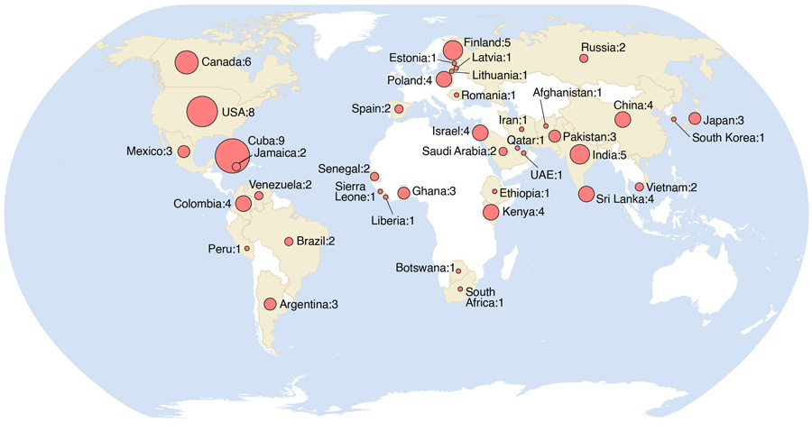
Figure 1. A map of the subject countries of the twentieth century national atlases included in Short’s bibliography (159). Map by Zhaoxu Sui.
It is often said that all maps reflect and express power, and that national atlases are perhaps some of the most explicit of all in making, showcasing, and expressing national agendas. Short, himself, writes that
The national atlas is a complex text. It is a scientific document, a tool of legitimation, a spatial claim, a textual appropriation of territory and an attempt to foster, encourage, and create a national community . . . it is an element in national ideological constructions encased in global scientific discourses. (2)
Short construes a national atlas as a rhetorical expression of the “cartographic power” of the state, a tool that can be used to envision state territories, consolidate national communities, and administer physical and social landscapes. His construal is supported by studies in critical cartography and critical political geography—studies that view maps not as natural or neutral representations, but instead as made-up arguments revealing the will of political powers, states, or nations.
Although this study primarily concerns national atlases created in the twentieth century, it does not ignore how the genre evolved alongside concepts of nationalism in Europe. Officially sponsored cartographic projects can be traced as far back as the fifteenth and sixteenth centuries in England and France, where maps of cities, fortifications, croplands, and pastures assisted landowners and rulers in administering and defending their realms. These early precursors to modern national atlases are discussed in Chapter 2, “The Early National Atlas,” while Chapter 3, “Cartographic Anxieties and the Emergence of the Modern National Atlas,” carries this history on into the pre-modern era. As European states gradually consolidated and modernized, previously indeterminate frontier zones gave way to territorial claims that were precisely demarcated both on maps and on the ground. This was also, and especially, true in the New World, where the collapse of the Spanish colonial empire gave birth to new states with serious “cartographic anxieties” about their uncertain and often unstable borders. Many of these states enthusiastically embraced the “cartographic power” of a national atlas to legitimize their own territorial claims and challenge the claims of others. Short describes how Venezuela, Peru, and Mexico each encompassed disputed territories in their national atlases and leveraged these depictions to consolidate their national identity—a use of cartographic power to secure territories that is still commonly practiced today in national atlases.
In Chapter 4, “Cartographic Ruptures and the National Atlas,” Short shows that national atlases need not come only from existing national states, but could contribute, as a catalyst and predictor, to the formation of new states. The National Atlas of Finland, for instance, was published while Finland was still an integral part of the Russian Empire. It showcased the uniqueness of Finland and served as an expression of Finnish nationalism that harmonized with the growing nationalist movements arising across Europe during the nineteenth century. Similarly, the first Polish Atlas—produced during World War I and published in 1918—was displayed at the Paris Peace Conference and was a key reference document supporting the re-birth of an independent Poland. Throughout the century, and across the world, national atlases have come to be seen as crucial documents for all nations, be they newly independent or as-yet aspirational; born of war, revolution, or negotiation. Political ruptures seemed to lead to the production of national atlases.
Chapter 5, “National Atlas,” places national atlases into international discourses. Short points out that almost all twentieth century national atlases tend to conform to a common “mapping language”—a broadly standardized set of conventions recognizable as associated with, and appropriate to, such publications. This standardized mapping language forms an integral part of an international discourse that transcends the readers’ various linguistic differences and cultural backgrounds and frames their understanding of the material presented. He also notes that throughout the century many states published separate versions of their national atlases in English—even when English was not one of that country’s national languages. This, too, is in line with what Short identifies as the international national atlas discourse: as the twentieth century’s most commonly used language, an English version could be accessible to more audiences and communities around the world.
In Chapter 6, “The Physical World of the National Atlas,” the author discusses how states used cartographic power to encircle, manage, and administrate physical spaces. Beginning in the early modern period, writers on a wide range of physical and environmental topics worked to define and refine vocabulary and grammar with which to describe the natural world. In fact, we can say that through their efforts these people essentially “produced” those sciences. In a parallel development, Short argues that states also came up with standards to describe and constantly construct physical spaces and environments in their national atlases; a process he has described as “a coproduction of science and the state” (85). National atlases employ these conventions to describe and explain the changes, alteration, and/or commodification of physical environments through narratives ranging from socialist economic planning in Soviet Union to the deracialization of land ownership in Kenya. These environments and processes, however, are often dynamic and contested, and despite their presentation in any one national atlas, one can find the same physical realities being depicted and labeled differently in different atlases across countries or editions.
Having shown how national atlases constantly construct physical spaces, Short turns, in Chapter 7, to “The Social World of the National Atlas,” the way national atlases have portrayed their own populations in order to “produce” a vision of the country’s human society. For example, he draws attention to certain generalized and abstract maps of social statistics in some early national atlases that purported to address such questions as where “moral” people lived or how diseases spread through particular populations—pointing out that these visual depictions can never be neutral or objective because every step of the collection, categorization, and rendering of the underlying data is filtered through prevailing state agendas. Many statistical atlases, in describing social categories, mixed together races, ethnicities, and languages: for example, he presents a map of South Africa showing classes for both “Afrikaans-speaking people” (a language) and “Native Groups” (an ethnicity). Divisions such as these are more securely based on ideological precepts than on scientific methods. Sometimes the categories do change between editions, but they all demonstrate the way national atlases construct the social landscapes that serve ruling classes’ best interests.
The text closes with Chapter 8—“The End of the National Atlas?”—a short summation followed by a look to the future of national atlases. Despite the decline of printed national atlases in recent decades, the rise of digital publication formats and portals allows Short to anticipate a new trend of producing something that he calls a Polyphonic Participatory Atlas, a step to advance the function of the national atlas as an “ideological state apparatus” (150) and provide a “participatory portal” (151) to give voices to different peoples that are usually obscured and racialized in traditional top-down state manifestations, an idea very similar to that of participatory mapping.
Throughout this book, Short consistently argues that national atlases are more than mere compilations of maps made by governments. Alongside his comprehensive review and descriptions of the maps and atlases, he engages in a critical analysis of how these maps reflected national wills and agendas, and, by contextualizing their contents and presentations, shows how the atlases themselves modified the construal of the world they supposedly depicted. For example, the 2000 edition of Atlas Nacional do Brasil showcases many topics, ranging from capital flows in and out of Brazil to negative aspects of economic development on infant health and mortality. Short argues that the critical examination of the Brazilian economy presented in this edition of the atlas, in the light of the country’s unmentioned domestic and geopolitical situation, is a way to revisit the country under the previous military dictatorship. Similarly, his in-depth analysis of the role played by the early Finnish and Polish atlases in bringing into existence independent Finnish and Polish states after the First World War, works to illuminate the role national atlases played in the emergence of numerous other nation-states in subsequent years.
Short’s comparisons of multiple editions of the national atlas of single countries also serve to uncover patterns of socio-political change. In his Chapter 4 comparison of different editions of the national atlas of Canada, he shows that the privately produced 1905 edition of The Imperial Atlas of the Dominion of Canada and the World depicts Canada as a wilderness making up one constituent part of a world-wide British Empire. By contrast, the following year’s edition, now entitled Atlas of Canada and produced by the Government of Canada’s Department of Interior, shows Canada as an independent country—highlighting its progress in urbanization and infrastructure while deemphasizing the imperial connection. Short regards this change to be indicative of the gradually changing status of Canada from that of a hard-won British possession to that of a dynamic, diverse, autonomous nation. These kinds of chronological comparisons also exist in other chapters. In the colonial Atlas of the Gold Coast, published in 1949, a large percentage of the atlas content concerns export-oriented commodities like cocoa and palm oils, whereas the 1960s era Atlas of Ghana focuses on more everyday goods for the people living there as citizens of free Ghana. Having these atlas contents compared in different years of publishing helps us enrich our understanding of how modern states continuously evolve and adjust such self-perceived properties as territories, goods, and international relations, and how those subtle ideological shifts are captured by political states in these atlases.
Short does not limit his study to national atlases produced in Western countries but heavily discusses those of the many newly independent countries in Africa and Asia. However, the absence of twentieth century national atlases of France, the United Kingdom, Italy, Switzerland, and Germany is notable. Is it because these countries do not publish national atlases, or did Short simply not, for some reason, care to discuss them? Given that these countries were technical, colonial, and/or ideological leaders of modern Western cartography, one suspects that a discussion of the evolution of their national atlases in these countries would be intriguing or at least deserving of mention.
There is little discussion in this book of the dramatic technical transition cartography underwent over the course of the twentieth century. The carefully crafted and drafted handmade maps in prestigious national atlases were effectively superseded by the products of digital technologies, as were the processes of collecting and collating the underlying physical and social source data. Short briefly mentions this finding in his last chapter, but this transition deserves—along with the role of the state in regulation and censorship—to be more carefully examined in its material contexts.
Similarly, this also leads into the challenges Short introduces in his last chapter — the one about the future — such as envisioning a more interactive and participatory format for national atlases. I anticipated learning more on how the increase of digital literacy among people and government officials influenced their national atlas mapmaking decisions and how national atlases could carve out their own niche—defining the purposes and audiences to be served in this new era of digital maps, and the contributions they can make to contemporary discourse.
In general, The Rise and Fall of National Atlas in the Twentieth Century is an enlightening read for cartographers, geographers, historians, and anyone interested in maps and geopolitics. It spans multiple knowledge disciplines from history, sociology, geography, and geopolitics, offering comprehensive observations and critical analysis about national atlases as projects condensed of political wills. It also inspires atlas collectors like me to revisit and compare atlases published by states, marking every cartographic design decision and every text to uncover deeper messages behind these pages.